| |

 |
Lorient area earthquake September 30, 2002 |
 Detection and location during the alert phase Detection and location during the alert phase
On Monday September 30, 2002 at 8:44 am (French time) (06:44 am (UT)), Brittany experienced its strongest earthquake in over 20 years. This earthquake measured 5.5 degrees on the open-ended Richter scale. The alert was given by the LDG (DASE geophysics laboratory), which has monitored the whole of France since the early 1960's via its network of 40 seismic stations. The on-duty seismologist, who had been automatically warned in the minute following the earthquake, sent out an initial analysis of the event to the relevant authorities 37 minutes later. He in particular determined the location of the epicenter (25 kilometers north-east of Lorient) and gave an initial estimate of its magnitude.
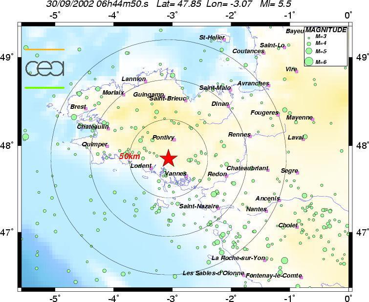
 The 8:44 am event (magnitude 5.5) The 8:44 am event (magnitude 5.5)
Characterization and location during the routine analysis
The CEA's expert seismologists provided a more precise location in the hour following the earthquake. This analysis above all confirmed the location, 10 km south of Quistinic, where a DASE monitoring network seismic station is located. It also provided an estimate of the various magnitudes associated with the event.
| Date |
30/09/2002 |
| Origin time |
06:44:48:02 (UT) |
| Latitude |
47 DEG 50
MN NORTH (47.84) |
| Longitude |
3 DEG 07
MN WEST (-3.21) |
| Magnitude |
5.7 (Ml)
regional magnitude
3.1 (Ms) surface magnitude
4.1 (Mb) teleseismic magnitude
4.6 (Md) duration magnitude |
|
This precise location demonstrates the wide range of magnitudes obtained (each magnitude corresponds to a particular analysis). The "overestimation" of the Ml magnitude (regional distance) is due to the presence of large-amplitude Lg waves, which confirms the shallow nature of this event. Yet it is this magnitude that is commonly used to characterize local earthquakes.
In the hours following the earthquake, eight aftershocks were recorded. Two had a magnitude of 3 and one a magnitude of 4 that was hardly felt but triggered another alert. These aftershocks are usual after a large earthquake. This local activity generally tends to decrease over a period ranging from a few hours up to several weeks.
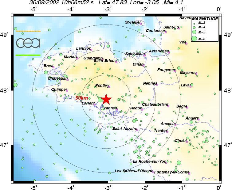
The 12:06 pm event (magnitude 4.1)
Detailed analysis and characterization of the event
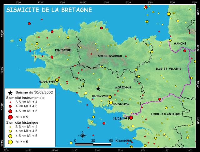
This event of natural origin is located on the South Armorican Shear Zone (SASZ), which is a large ancient (Hercynian) tectonic structure extending from the Iroise Sea (off the Pointe du Raz headland) to the Limousin area and subdivided into several branches. In the epicentral area in particular, the SASZ splits into two WNW-ESE and NW-SE branches. Movements on this structure, derived from focal mechanisms, indicate an extension associated with a right-slip fault. These incidents, dating over 300 million years, are associated with a deep structure. They are the seat of a recent deformation, as witnessed by the resumed erosion and diffuse but steady seismicity.
Previous events
This event is the largest earthquake recorded in north-west France since September 7, 1972, the date of the Oléron Island earthquake (magnitude 5.7).
The two events closest to Monday's earthquake occurred less than 15 km away, respectively on January 31, 1996 and on April 24, 2001. In both cases magnitude was 3.3. Within a 100 km radius, the last significant event occurred north of Saint-Nazaire on March 13, 1993 with a 4.6 magnitude. To find a recent earthquake on the southern branch of the South Armorican Shear Zone, we need to go further south-east, to Vendée near La Roche-sur-Yon (June 8, 2001, magnitude 5.1). The oldest event recorded by the CEA network in this area occurred on January 2, 1959. This was a 5.2 magnitude earthquake that occurred east of Quimper. The most recent event, with a 3.1 magnitude, occurred 20 km south-east of Quimper on September 27, 2002 at 7:40 pm.
|
)
)