| |

 |
Saint-Dié area earthquake February 22, 2003 |
 Detection and location during the alert phase Detection and location during the alert phase
On Saturday February 22, 2003 at 9:41 pm (French time) (8:41 pm (UT)), an earthquake of magnitude Ml=5.9 occurred 21 kilometers west of Saint-Dié (Vosges). This earthquake triggered an alert on the DASE seismic monitoring network. The on-duty seismologist, who had been warned automatically, sent out an initial analysis of the event to the relevant authorities 35 minutes later. He in particular gave an initial estimate of the epicenter's location and the earthquake's magnitude.
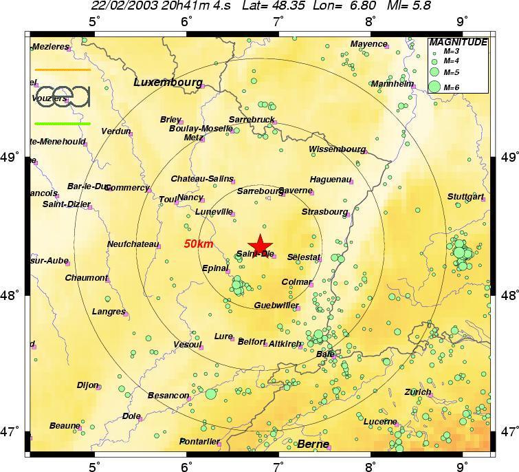
 Preliminary location of the event (green dots represent natural seismicity)
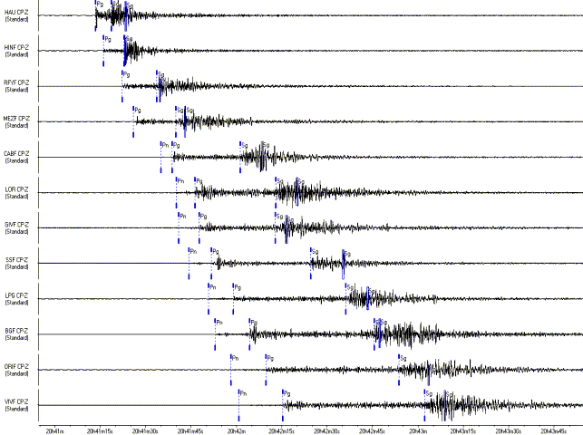
Signals associated with the event from various national network stations
Characterization and location during the routine analysis
LDG seismologists, whose task is to publish the bulletin of earthquakes in the vicinity, then determined the location more precisely. This work above all produced a more accurate location, based on over 120 pointings. It also provided an estimate of the various magnitudes associated with the event:
| Date |
22/02/2003 |
| Origin time |
20:41:06.9 (UT) |
| Latitude |
48 DEG 20
MN NORTH (48.34) |
| Longitude |
6 DEG 41
MN EAST (6.68) |
| Depth |
14 km |
| Magnitude |
5.9 (Ml)
regional magnitude
4.1 (Ms) surface magnitude
5.0 (Mb) teleseismic magnitude |
|
This precise location demonstrates the wide range of magnitudes obtained (each magnitude corresponds to a particular analysis). Ml magnitude is commonly used to characterize local earthquakes.
In the 48 hours following the event, five major aftershocks with magnitudes above 3 were recorded and triggered several new alerts. Several hundreds of minor events were detected thanks to the nearby (less than 60 km away) HAU and HINF stations. These aftershocks are usual after a large earthquake. This local activity generally tends to decrease over a period ranging from a few hours up to several weeks.
The chart below indicates the characteristics of the main events recorded during the 48 hours following the main earthquake:
|
Date
|
Origin time
|
latitude (N) |
longitude (E) |
magnitude (Ml) |
|
22/02/2003 |
20:41:06 |
48.34 |
6.67 |
5.9 |
|
22/02/2003 |
20:54:26 |
48.31 |
6.63 |
3.7 |
|
23/02/2003 |
00:16:43 |
48.31 |
6.63 |
3.3 |
|
23/02/2003 |
14:53:48 |
48.31 |
6.60 |
3.4 |
|
23/02/2003 |
23:58:53 |
48.29 |
6.61 |
3.6 |
|
24/02/2003 |
00:35:43 |
48.30 |
6.62 |
3.3
|
|
The location of the main aftershocks appears to indicate a south-westerly migration of the events.
Seismotectonic setting
In Saint-Dié area, three tectonic directions can be observed (refer to the Figure below):
|
 |
The N80° direction, represented by the Lalaye-Lubine Shear Zone, main characteristic of the Variscan orogeny (that extends to the Parisian basin via the Vittel and Bray faults); |
| |
|
The submeridian direction (N10°), main axis of the Rhine trench, which is linked to the Oligocene rifting that can be observed in numerous places in the Vosges massif; |
| |
|
The N130° direction, characterized by ancient faults that were reactivated by the vertical exaggeration of the Vosges during the Mio-Pliocene. |
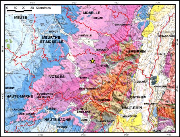
Regional geological context
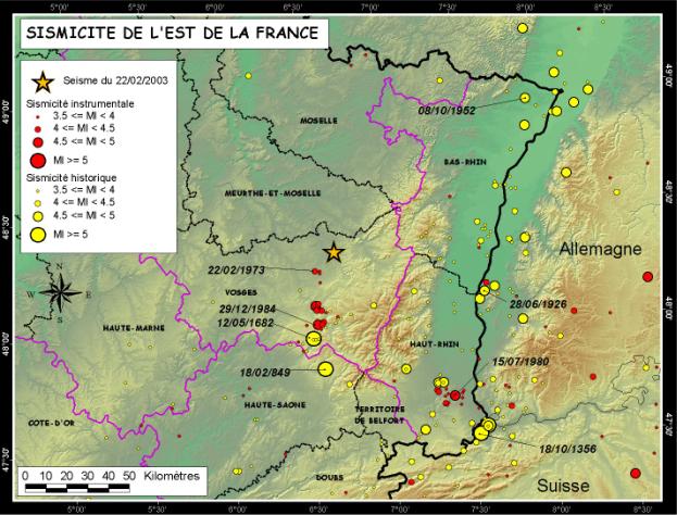
Note that the instrumental and historical seismicity in this area (refer to Figure below) revealed the active nature of the submeridian directions, particularly in the Remiremont area, where an earthquake of epicentral intensity VIII occurred in 1682 and a seismic episode occurred in 1984-85 (magnitude 4.8).
When this memorandum was written, it was not possible to precisely determine the direction of the fault that triggered the earthquake.
|
)
)