| |

 |
Preliminary modeling of the tsunami caused by the Algiers earthquake, May 21, 2003 |
 Observations and models Observations and models
Following the Algiers earthquake on May 21, 2003 (refer to the EMSC special page), sea level disturbances were observed on the coasts of the Balearic Islands (Majorca, Minorca and also Ibiza). Witnesses reported 1 to 2 m high waves for an average period of 10 to 12 minutes (in Majorca) (refer to example here). In Minorca, a dozen boats sank and several others were damaged. The Palma tide gauge recording (Figure 1, tidal curve provided by Instituto Espanol de Oceanografia) indicates a maximum water height of approximately 60 cm.
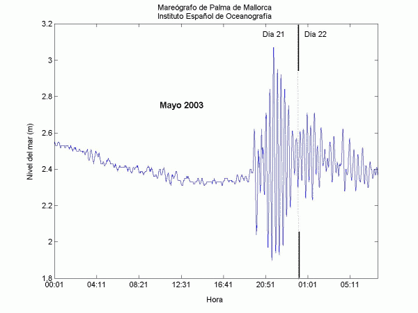
 Figure 1: Majorca tidal curve (provided by María Jesús Garcia, IEO)
Changes in the sea level can be related to the tsunami generated, either by underwater coseismic deformation caused by the fault associated with the earthquake, or by a submarine landslide.
Firstly, we test a source related to the coseismic deformation, which has been estimated using the seismological parameters determined in the Harvard CMT solution and a simple elastic model (Okada, 1985). The primary deformation (Figure 2) results in an average fault displacement of 85 cm.
However, the first seismological inversions indicate a shallower depth than the one used here (probably less than or equal to 10 km). Therefore, the surface displacement could be greater than the one obtained here.
| Fault dimension (kmxkm) |
40x20 |
| Strike,
dip, rake |
56°,
46°, 71° |
| Seismic moment (Nm) |
0.201 1020 |
| Rigidity
(Nm2) |
30 109 |
| Epicenter |
3.52°E - 36.98°N |
| Depth (km) |
17 |
|
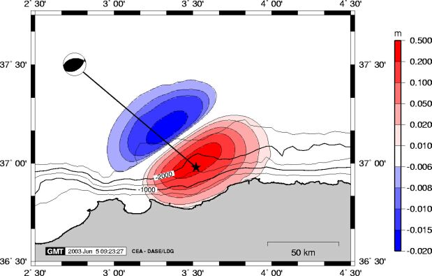
Figure 2: Primary coseismic deformation calculated using the above parameters
We assume that the primary deformation is fully and instantly transferred to the water surface, and then the tsunami waves are generated by the return to equilibrium. Tsunami wavelengths are greater than water depth, therefore the long-wave theory is valid. The simulation is based on a finite difference method for solving hydrodynamic equations, including non-linear terms.
We use bathymetric charts to describe the propagation medium based on wave propagation speed c, where c= (gh)1/2. To determine amplification on approaching the coasts, the calculation requires the use of nested grids. We use worldwide bathymetric data derived from satellite-based altimetry (compiled by Smith and Wessel, 1997), and have developed a 2' (approximately 4 km) grid to describe the western Mediterranean Sea, a 30'' (approximately 900 m) grid for the Balearic Islands, and 10'' (approximately 300 m) grids for Majorca and Minorca (Figure 3).
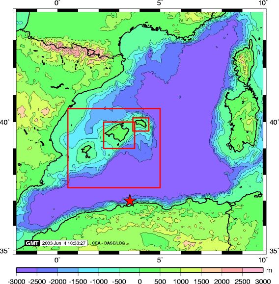
Figure 3: Calculation domain and grid location in the Balearic Islands.
Results
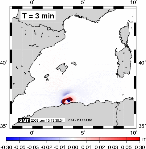
The waves reach the Balearic Islands approximately 30 to 40 minutes later, which is compatible with the arrival time deduced from the tide gauge data (Figure 4).
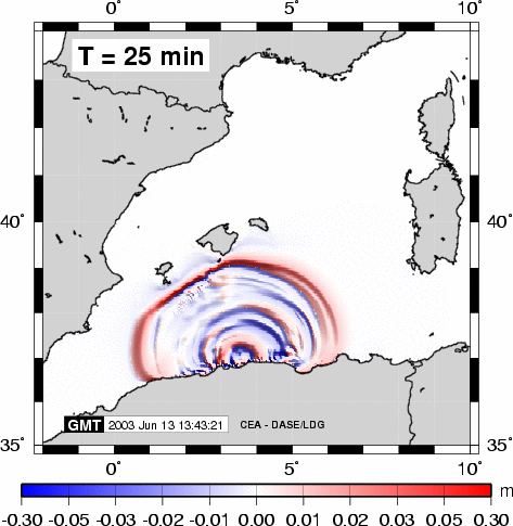
Figure 4: Water surface calculated after a propagation of 25 minutes.
During propagation, the maximum heights the water reaches (Figure 5) define the zone of maximum tsunami energy. This zone is perpendicular to the fault azimuth (Hébert et al., 2001). The Balearic Islands thus appear well exposed to tsunamis occurring in this epicentral area of Algeria.
The propagation is also available as an animated image (.gif, ~8 MB) or a video (.mpeg,
530 KB).
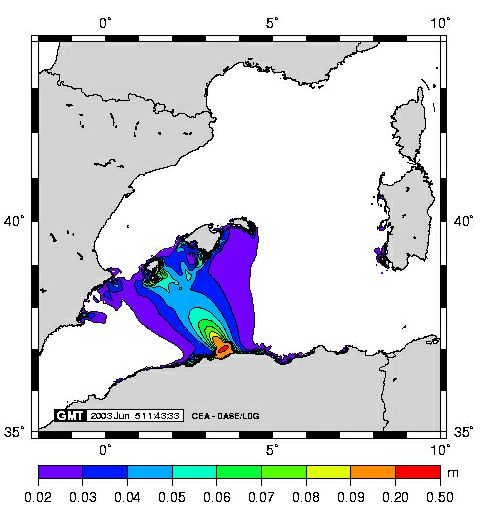
Figure 5: Maximum water heights after a propagation of 1 hr 30 minutes.
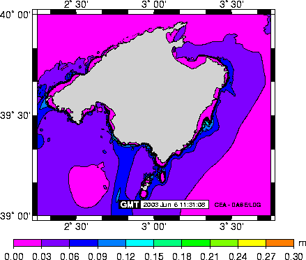
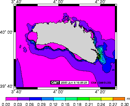
In the Balearic Islands, this preliminary calculation cannot reproduce detailed observations. It is therefore essential to produce detailed bathymetric charts based on the tide gauges. Figures 6 and 7 do not show any amplification worthy of note, but they are not always significant at this stage. We can see that the steep underwater slopes around the islands can induce wave reflection.
Nevertheless, this calculation reveals some relatively stronger amplification zones in the towns that effectively suffered the most damage (Porto Cristo in Majorca, and Mao in Minorca).
More detailed studies are underway to achieve more accurate local calculations.
 |
 |
| Figure 6: Maximum water heights reached in Majorca. |
Figure 7: Maximum water heights reached in Minorca. |
Comments
- The model presented here is extremely preliminary and is based on approximate bathymetric data only. Detailed data received from the harbors are required to reproduce observed amplifications.
- However, this model shows that the coseismic source may explain the observations made in the Balearic Islands, regardless of the existence of a submarine landslide source. The main shock was followed by numerous turbidity currents on the Algerian Margin, but their role in the triggering of the tsunami is not proven.
- On the whole, the observations made along the Algerian coast are more moderate than in the Balearic Islands, but a specific study on the tsunami risk in the Mediterranean Sea could help to more accurately determine the degree of risk to which the Algerian coasts are exposed (refer for example to Yelles-Chaouche, 1991).
- Finally, it is necessary to underline the fact that the Mediterranean tide gauge network is relatively ill-equipped for these applications where studied signal periods are typically shorter than 20 to 30 minutes. Tide gauges dedicated to the study of tides or geodesy cannot be used in this context. A dense network dedicated to these signals would even enable tide gauge record inversion techniques to be implemented, and this could help to constrain underwater seismic sources (as in Japan, refer to Tanioka and Satake, 2001, for example).
References
Hébert, H., P. Heinrich, F. Schindelé, et A.
Piatanesi, Far-field simulation of tsunami propagation in
the Pacific Ocean: impact on the Marquesas Islands (French
Polynesia), J. Geophys. Res., 106, C5, 9161-9177, 2001.
Okada, Y., Surface deformation due to shear and tensile faults
in a half-space, Bull. Seismol. Soc. Am., 75, 1135-1154, 1985.
Smith, W.H.F., et Sandwell, D.T., Global seafloor topography
from satellite altimetry and ship depth soundings, Science,
277, 1956-1962, 1997.
Tanioka, Y., et K. Satake, Detailed coseismic slip distribution
of the 1944 Tonankai earthquake estimated from tsunami waveforms,
Geophysical Research Letters, 28, 1075-1078, 2001.
Yelles-Chaouche, A., Coastal Algerian earthquakes: a potential
risk of tsunamis in western Mediterranean? Preliminary investigation,
Science of Tsunami Hazards, 9, 47-54, 1991.
References on the subject published by the laboratory
Guibourg, S., P. Heinrich and R. Roche, Numerical modeling of
the 1995 Chilean tsunami. Impact on French Polynesia, Geophysical
Research Letters, 24, 775-778, 1997.
Hébert, H., P. Heinrich, F. Schindelé, and A.
Piatanesi, Far-field simulation of tsunami propagation in the
Pacific Ocean: impact on the Marquesas Islands (French Polynesia),
J. Geophys. Res., 106, C5, 9161-9177, 2001.
Hébert H., F. Schindelé, and P. Heinrich, Tsunami
risk assessment in the Marquesas Islands (French Polynesia)
through numerical modeling of recent and generic far-field events,
Natural Hazards and Earth System Sciences, 1, 233-242, 2001.
Hébert, H., A. Piatanesi, P. Heinrich, F. Schindelé,
and E. A. Okal, Numerical modeling of the September 13, 1999
landslide and tsunami on Fatu Hiva Island (French Polynesia),
Geophys. Res. Lett., 29, 10, doi:10.1029/2001GL01374, 2002.
Heinrich, P., A. Mangeney, S. Guibourg, R. Roche, G. Boudon,
and J.-L. Cheminée, Simulation of water waves generated
by a potential debris avalanche in Montserrat, Lesser Antilles,
Geophysical Research Letters, 25, 3697-3700, 1998.
Heinrich, P., F. Schindelé, S. Guibourg and P.F. Ihmlé,
Modeling of the February 1996 Peruvian tsunami, Geophysical
Research Letters, 25, 2687-2690, 1998.
Heinrich, P., R. Roche, A. Mangeney and G. Boudon, Modéliser
un raz de marée créé par un volcan, La
Recherche, Mars 1999, 66-71, 1999.
Heinrich, P., S. Guibourg, A. Mangeney, and R. Roche, Numerical
modeling of a landslide-generated tsunami following a potential
explosion of the Montserrat Volcano, Physics and Chemistry of
the Earth, 24, 16-168, 1999.
Heinrich, P., A. Piatanesi, E. Okal, and H. Hébert, Near-field
modeling of the July 17, 1998 event in Papua New Guinea, Geophysical
Research Letters, 27, 3037-3040, 2000.
Heinrich, P., A. Piatanesi, and H. Hébert, Efficiency
of deep submarine landslides in producing tsunamis: the 1998
Papua New Guinea event, GJI, 145, 97-111, 2001.
Schindelé, F., D. Reymond, E. Gaucher and E.A. Okal,
Analysis and automatic processing in near-field of eight 1992-1994
tsunamigenic earthquakes: improvements towards real-time tsunami
warning, Pure and Applied Geophysics, 144, 381-408, 1995.
|