
 |
Study of the Besançon area earthquake February 23, 2004 |
MEMORANDUM FROM THE LABORATORY FOR DETECTION AND GEOPHYSICS (LDG)
 Detection and location during the alert phase Detection and location during the alert phase
On February 23, 2004 at 5:31 pm UT (6:31 pm French time), a seismic event of magnitude MI = 5.5 occurred about 20 km east of Besançon (Doubs). This earthquake triggered an alert on the CEA's seismic monitoring network. This alert was processed and sent out within 15 minutes by the duty seismologist:
| The LDG detected a seismic event approximately
23 km east of Besançon (25)
Date = 23/02/2004
Origin Time = 5:31:20.0 PM (UT)
Latitude = 47 DEG 19 MN NORTH
Longitude = 6 DEG 20 MN EAST
Magnitude = 5.3 (Ml) |
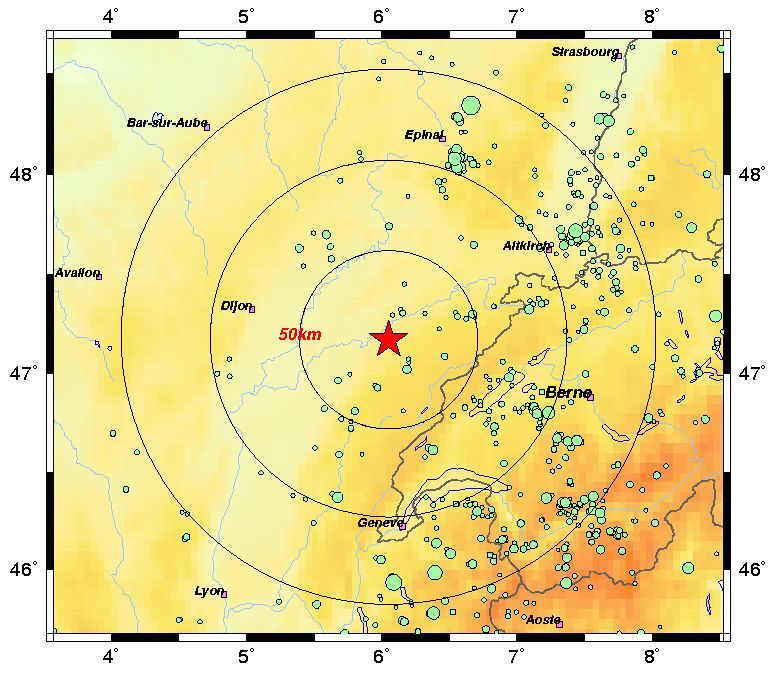
The map in Figure 1 shows the location together with the previous seismicity for the area. Figure 2 shows the signals for various stations in the national network.
 |
 |
Figure 1 - Map of location and previous seismicity in the area. |
|
 |
|
Figure 2 - Signals relating to the event. |
|
Characterization and location during the routine analysis
A more precise location was determined by the CEA analysts in charge of the local earthquake bulletin. This study particularly enabled them to narrow down the location (more than 200 pointings) and to estimate the different magnitudes associated with the event:
| Date |
23/02/2004 |
| Origin Time |
5:31:21.3 PM (GMT) |
| Latitude |
47 DEG 17 MN NORTH (47.28) |
| Longitude |
6 DEG 16 MN EAST (6.27) |
| Depth |
20 km |
| Magnitude |
5.5 (Ml) local magnitude
4.7 (Md) duration magnitude
4.2 (Mb) teleseismic magnitude |
|
Finally, at the time of writing this memo (February, 24 at 1:00 pm), no aftershock has been detected by the CEA network.
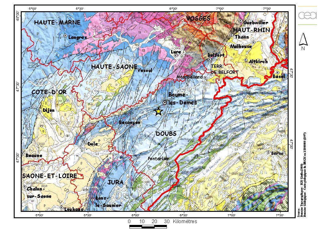
Last year, a slightly larger event (Ml = 5.9) occurred some 100 kilometers to the north of the earthquake, near Saint Dié, producing roughly a thousand aftershocks. It is important to note that these two events occurred in different contexts. The Saint Dié earthquake was linked to tectonic activity in the Rhine trench whereas the Besançon earthquake was directly linked to the tectonics of the Jura mountains (see Figure 4).
Seismotectonic setting
The Besançon earthquake is located 23 km NE of the town of Besançon. It is located under the décollement of the northern front of the Jura mountains. This event is significant since its magnitude (Ml = 5.5) is the highest recorded in the area since the deployment of modern seismological networks (1962).
The Jura has been characterized by compressive tangential tectonics since the Upper Miocene, with local strike-slip faulting, linked to the NW-SE Alpine push and to the decollement of the cover along the evaporitic Trias. On the surface, the deformation is accommodated by folds and thrusts (oriented N90°E and N-S West) and strike-slip faults oriented N0-20°, probably linked to basement faults. In the Besançon area, the Jura front splits into two successive thrusts oriented NE-SW, emerging respectively at the foot of the Doubs and the Ognon. The distinctive morphology, significant local terracing of the two rivers and the instrumental and historical seismicity (Besançon 1828, I0 = VII) underline the recent activity of these structures.
The largest earthquake recorded in the area is the October 26, 1828 earthquake of maximum intensity = VII (MSK). It occurred around Besançon at the frontal area of the Jura (see Figure 4). The remainder of seismic activity is mainly concentrated at the border with the Alps. The southern part of the Jura is particularly characterized by a concentration of historical earthquakes located near the Alps, the largest one being the Bugey-Chautagne earthquake of February 19, 1822, I0 = VII-VIII (MSK). Lastly, some authors have put forward the theory that an active Hercynian structure, under the frontal thrust of the Jura, may be the source of the Basel earthquake in 1356 (I0 = IX (MSK)).
The entire Jura front is active, characterized by moderate instrumental seismicity (Ml < 4-4.5) and historical seismicity which correlates well with the frontal faults where recent movements have been recorded.
An initial analysis between morphology and seismicity within the Jura shows some good correlations with sub-meridian left-lateral strike-slip faults and the thrusts of the upper Doubs valley. The thickness of these series (a few kilometers) suggests that these faults have limited seismogenic potential compatible with the recorded historical earthquakes.
The event of February 23, 2004 is therefore a significant event for the Jura, comparable in importance to certain recorded historical events. It appears to have occurred on a crustal structure of the Jura thrust. The magnitude of this event, which is nevertheless moderate, did not appear to cause any surface rupture. A more precise seismological analysis should enable us to further develop this preliminary analysis.
 |
|
Figure 3 - Regional geological context. |
|
 |
|
Figure 4 - Historical and instrumental seismicity. |
|
|