
 |
WEST INDIES EARTHQUAKE November 21, 2004
|
 Description of the event Description of the event
On Sunday November 21, 2004 at 7:41 am local time, (i.e. 12:41 pm in mainland France or 11:41 am UT), Guadeloupe and its surrounding islands were hit by a strong earthquake of magnitude above 6 on the Richter scale.
Location of the event
As this event triggered the alert system operated by the European-Mediterranean Seismological Centre (EMSC), it was immediately located by the on duty seismologist at the DASE/LDG. The location of this event was calculated using a set of measurements available in the area. It locates the event about 30 km south of Guadeloupe, just by the Saintes archipelago (see chart and map below). The magnitude of this event (Ms=6.3) makes it a significant event for this area.
Date |
Origin time |
Latitude |
Longitude |
Magnitude (Mb)* |
Magnitude (Ms) **
|
21/11/2004 |
11:41:04 am |
15° 43’ North |
61° 44’ West |
6.4 |
6.3
|
* Teleseismic magnitude, ** Magnitude de surface
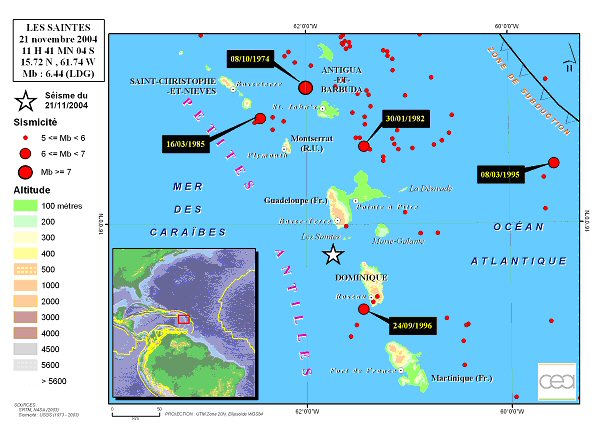
Within the hours following this earthquake, a significantly high number of aftershocks (over 1000) were detected, particularly by the seismic stations of the International Monitoring System of the Comprehensive Nuclear Test-Ban Treaty (CTBT), set up by the CEA/DASE on the neighboring islands of La Desirade and Martinique (over one hundred km away from the epicenter). Among these aftershocks, 5 recorded a magnitude above 5 (see following chart):
Date |
Time |
Magnitude |
21/11/2004 |
6:52:58 pm |
5.6 |
21/11/2004 |
11:47:39 am |
5.1 |
21/11/2004 |
1:36:55 pm |
5.1 |
21/11/2004 |
9:23:50 pm |
5.1 |
21/11/2004 |
11:56:26 am
|
5.0 |
Detailed analysis of the event
The detailed study of the seismic recordings was then used to better constrain the depth and to specify the characteristics of the fault that ruptured. The figure and chart below indicate the final result, showing the focal mechanism (fault orientation and slip direction) and the comparison between the P-wave recorded on the seismograms (in black) on 9 seismic stations surrounding the earthquake and the wave of the seismograms (in red) calculated from a model of a normal fault oriented NW-SE.
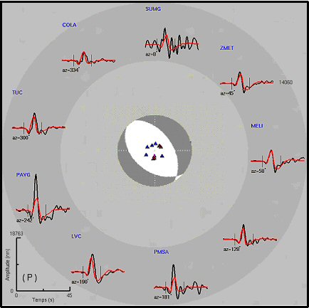
The comparison between observations and simulations is relatively consistent.
Seismic moment |
8.0x10¹⁸ N.m |
Used frequency band |
[0.017-0.35] Hz |
Strike |
131° |
Dip |
42° |
| Rake |
-103° |
| Depth |
3 km |
Data |
IRIS and CEA/DASE networks |
Regional seismotectonic setting
This earthquake occurred at the rear of the subduction zone where the Atlantic and Caribbean plates meet, in an area of little activity during the past decades. This type of structure is most often characterized by deep-focus earthquakes situated near the upper edge of the plunging plate (in this case the Atlantic plate). Due to its shallow depth and related focal mechanism, the earthquake of November 21, 2004 does not match the seismic profile associated with the plunging plate. It is clearly linked to reactivation of a shallow fault. This confirms that this domain is subjected to surface rifting (a characteristic of back-arc basins) and liable to produce destructive earthquakes on a local scale.
Further information
Visit the websites of the French Permanent Accelerometric Network (RAP) and the website of Institut de Physique du Globe de Paris.
|