
 |
CHAMONIX EARTHQUAKE (HAUTE-SAVOIE) September 8, 2005
|
 Description of the event Description of the event
On September 8, 2005 at 11:27:20 am UT (i.e. 1:27:20 pm local time), an earthquake of local magnitude ML = 5.3 occurred in the far north-eastern part of the valley of Chamonix, about 35 km east of Bonneville (74), at latitude 46.03 N and longitude 6.96 E (Figure 1). Given its magnitude, this event was recorded on all the CEA-DASE seismic network stations (Figure 2).
The event was followed, within the next 12 hours, by seven aftershocks, two of which (of magnitude 3.5) were also felt.
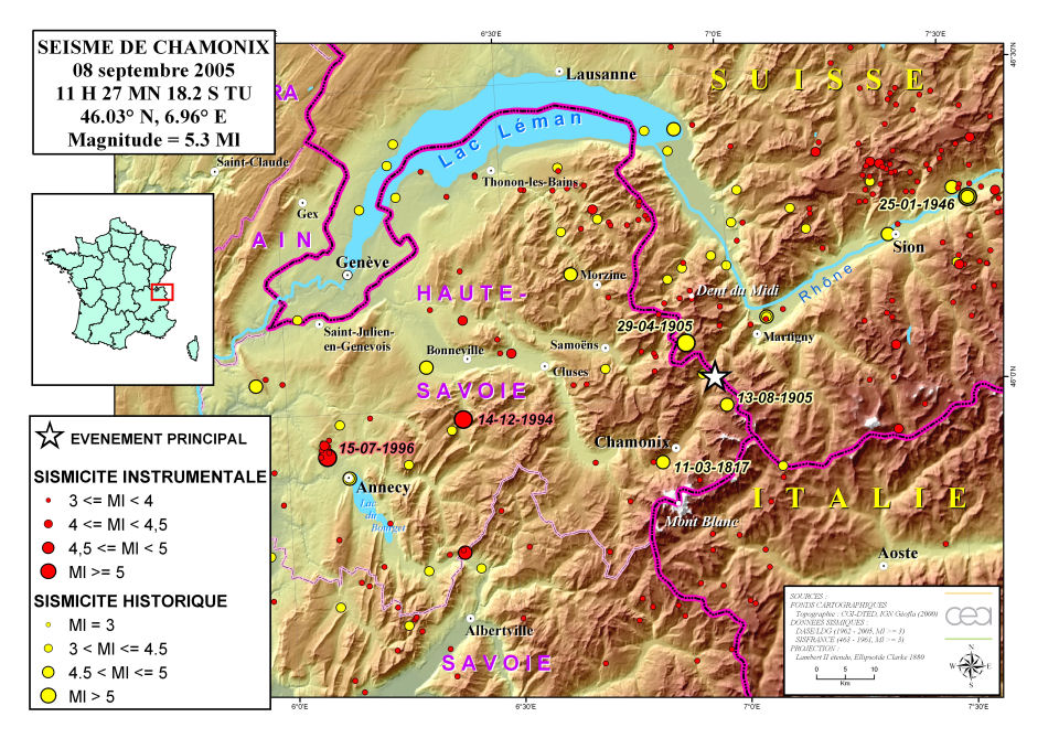
Figure 1: Location of the event of September 8, 2005 at 11:27 am UT (white star) and instrumental and historical seismicity recorded in the LDG database (red dots).
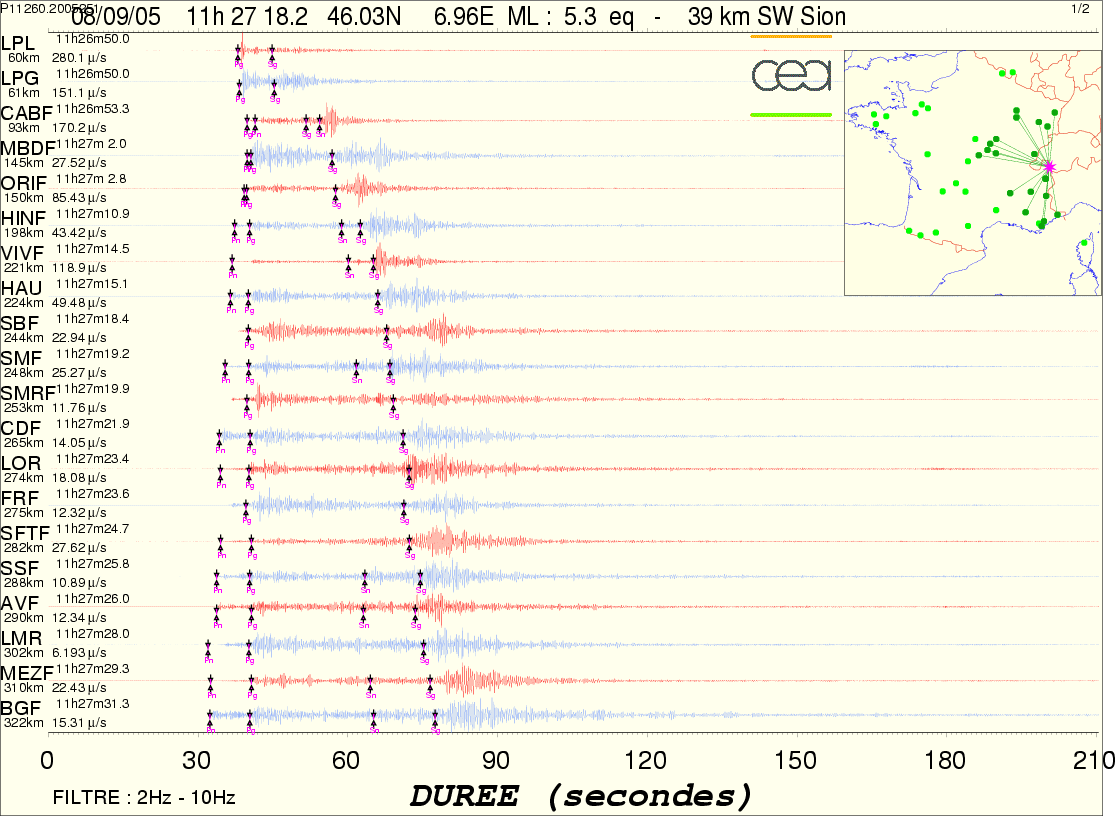
Figure 2: Seismic signals recorded for the September 8, 2005 earthquake
The main event triggered an alert on the CEA-DASE seismic monitoring network, which was sent to the Civil Defense Office and the relevant authorities by the duty seismologist within 20 minutes. This very shallow event was felt throughout the valley of Chamonix and even as far as Grenoble.
The following chart includes the characteristics of events that occurred within 24 hours of the main shock.
| Main event |
Date |
Time (UT) |
Latitude (°) |
Longitude (°) |
Magnitude (ML) |
| 08/09/2005 |
11:27:20 am |
46.03 N |
6.96 E |
5.3 |
| Aftershocks |
08/09/2005 |
11:29:03 am |
46.03 N |
6.94 E |
3.7 |
08/09/2005 |
11:33:08 am |
46.04 N |
6.97 E |
3 |
08/09/2005 |
11:53:12 am |
46.08 N |
6.97 E |
3.5 |
08/09/2005 |
00:25:33 pm |
46.06 N |
7.00 E |
2.3 |
08/09/2005 |
02:10:03 pm |
46.05 N |
6.90 E |
3.5 |
08/09/2005 |
4:50:07 pm |
46.05 N |
6.90 E |
2.8 |
08/09/2005 |
9:48:59 pm |
46.07 N |
7.02 E |
2 |
Four earthquakes of magnitude below 2.5 hit the same area on September 3 and 5.
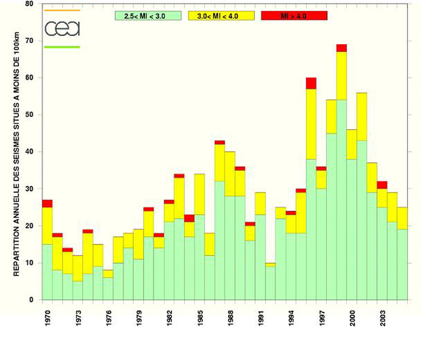
Figure 3: Histogram of seismicity in the vicinity of Chamonix since 1970.
Previous seismicity and seismotectonic setting
The Chamonix earthquake of September 8, 2005 is located near the French-Swiss border between the towns of Chamonix and Martigny, close to the Barberine-Emosson lakes.
This area of the Alpine mountain range is an area of the external Alps prone to recurrent seismicity.
The event follows a series of minor earthquakes (Ml <=2) observed in early September.
It is located close to the epicenter of the Chamonix earthquakes of March 11, 1817 (maximum intensity of about VII), and also close to those of 1905 whose main event, on April 29, was felt in a large part of south-east France, and caused significant damage in Argentière and Chamonix (maximum intensity of VII-VIII). This earthquake had been followed by an event of maximum intensity VII causing damage in Chamonix on August 13, 1905.
Given the location of the swarm of aftershocks, the extremely shallow nature of the main shock and the type of focal mechanism, the September 8, 2005 event could be attributed to movement on the Vallorcine fault. This N020 oriented normal fault, situated between the Mont Blanc and Aiguilles Rouges massifs, is steep (dip 70SE) with a slight slip component. This fault had already been suspected to be the source of the 1905 events.
Initial Version : 09/09/05 - Last update : 12/09/05
|