 |
 |
 |
|
 |
|
 |
|
|
|
Scientific files |
|
|
| |
 |
SOUTH OF JAVA EARTHQUAKE AND TSUNAMI
July 17, 2006 |
 Quick access : Quick access :
- Description of the earthquake
- Seismotectonic setting
- Kinematic inversion
- Tsunami
- Animation (9.5 MB)
Description of the earthquake
A major earthquake occurred on July 17, 2006 about 200 km off the south coast of Java Island at 8:19 am UT. This earthquake produced a tsunami which killed several hundred people on the southern coast of Java Island.
The characteristics of the earthquake are as follows:
| Date: |
July 17, 2006 |
| Origin time: |
08:19:23 am (UT) (3:19 pm local time) |
| Latitude: |
9.24 South |
| Longitude: |
107.36 East |
| Depth: |
10 km |
| Magnitude: |
7.5 (Mw CEA/DAM estimation) |
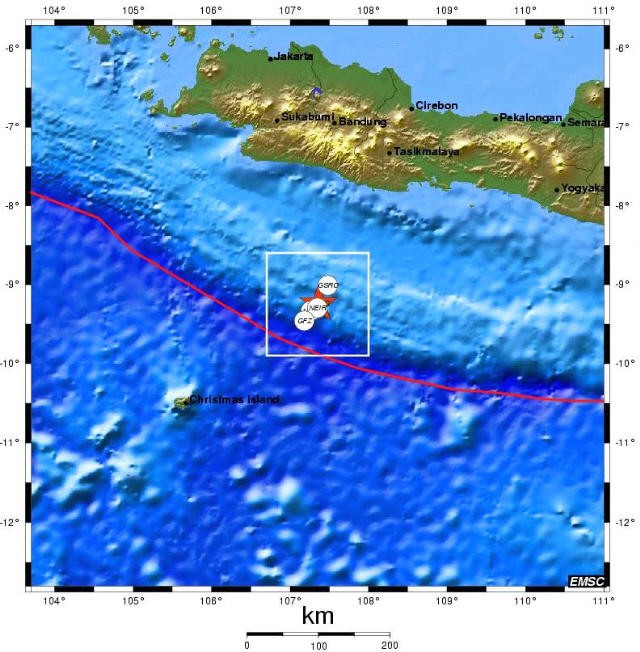
 Figure 1: Location of the July 17, 2006 earthquake. The red star indicates the EMSC location compared to the locations of other international agencies. Figure 1: Location of the July 17, 2006 earthquake. The red star indicates the EMSC location compared to the locations of other international agencies.
The quick estimations based on body waves produced very low values of magnitude mb=5.5. The EMSC alert was given at the arrival of the Rayleigh waves only, i.e. one hour after the earthquake. A warning message was sent out at 09:46 am UT with a magnitude estimation of Mw=7.2. All the warning centers issued an estimation ranging between 7.1 and 7.3 within the first hours. Thus the CEA/DAM station in Pamatai (Tahiti) determined a magnitude of Mw=7.3. Following a more detailed analysis of the records, the magnitude was revised to Mw=7.7 by the Harvard Center at 2:32 pm.
This earthquake, characterized as a slow earthquake, occurred in the shallow part of the subduction zone near the oceanic trench. Such events often generate large local tsunamis. It appears that this earthquake was felt in buildings in Jakarta but not along the south coast of Java Island where lives were unfortunately lost.
Seismotectonic setting
Along Java Island the Australian plate is plunging (subducting) NNE beneath the Sunda plate at a rate of about 6 cm/year. This process is generating a volcanic arc with volcanoes running parallel to the subduction trench.
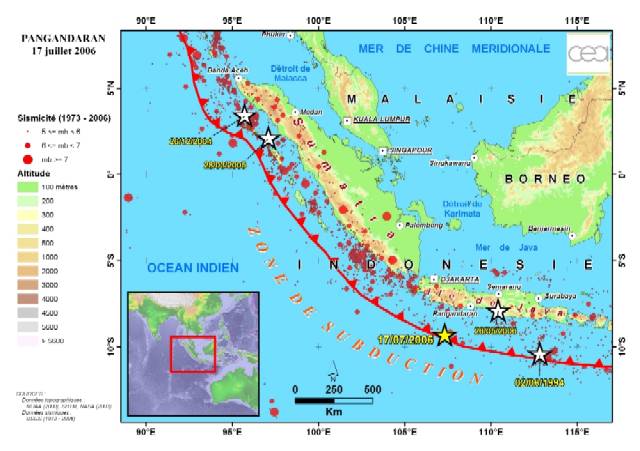
Figure 2: The earthquake on July 17, 2006 occurred at the subduction zone between the Australian plate to the south-west, and the Sunda block to the north. It is comparable to the earthquake of June 2, 1994, which occurred further east. This map also shows the destructive earthquake of December 2004 together with the recent earthquake of May 2006, which killed thousand of people in the Yogyakarta area.
Major earthquakes, associated with this seismotectonic setting, mainly located at sea, occur at the interface between the two plates like the Sumatra earthquake of December 2004, further north.
A similar earthquake (Mw=7.8), a thrusting event at very shallow depth, hit Java Island in 1994 (see following table) and caused a large tsunami (~200 victims).
YEAR |
LOCATION |
MAGNITUDE |
RUNUP MAX. |
VICTIMS |
1835 |
Sumatra |
? |
? |
? |
1881 |
Andaman |
? |
? |
5000? |
1883 |
Krakatau |
volcano |
38 m |
36 000 |
1965 |
Buru, Moluques |
7,5 |
4 m |
71 |
1967 |
Sulawesi South |
5,8 |
|
58 |
1968 |
Sulawesi Center |
7,4 |
10 m |
200 |
1969 |
Sulawesi South |
6,9 |
|
64 |
1977 |
Sumba |
8 |
15 m |
189 |
1992 |
Flores |
7,5 |
26 m |
1960 |
1994 |
Java East |
7,8 |
14 m |
238 |
1996 |
Biak, Irian Jaya |
8 |
7 m |
110 |
2004 |
NW Sumatra |
9 |
51 m |
230 000 |
List of main historic Indonesian earthquakes (source: French TSUNARISQUE project, F. Lavigne).
Kinematic inversion
Kinematic inversion of long-period data (national and IRIS data) results in a subhorizontal reverse fault focal mechanism with a dip of 18° to north/north-east (Figure 3). The magnitude of Mw=7.5 was calculated from body waves. The 1.2 km/s rupture velocity estimation indicates a slow earthquake with the potential to generate large tsunamis.
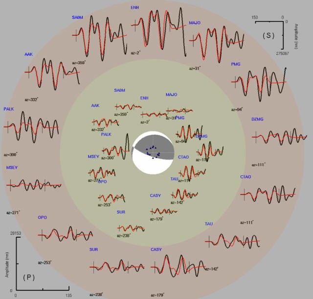
Figure 3: Inversion results in a magnitude of Mw=7.5 with two slip zones. The rupture length ranges between 70 and 100 km with an unilateral rupture towards the east, confirmed by the distribution of aftershocks.
Tsunami
An alert bulletin was issued by the PACIFIC TSUNAMI WARNING CENTER on July 17, 20 minutes after the earthquake. Given the magnitude of 7.2 (since then revised to Mw=7.7 by Harvard) and the low amplitude recorded by a tide gauge east of Java, the alert was only given for Indonesia and Australia (regional tsunami).
According to the available information issued by the media and the aid agencies on the spot, the more strongly struck area was Pangandaran, a small seaside resort located in the south of Java, in front of the epicentral area. More than 500 victims have been reported.
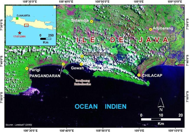
Figure 4: Location of main sites struck by the tsunami of the earthquake on July 17, 2006
We must also point out that there is little reliable and quantitative information currently available in Java for characterizing and mapping water heights on the coast. Field surveys will probably be conducted in the next few days.
The present observations on a few distant tide gauges (Figure 5) show water heights lower than 10 cm east of Java. The maximum tide gauge measurement (40 cm) has been recorded several thousands kilometers away on Rodrigues Island.
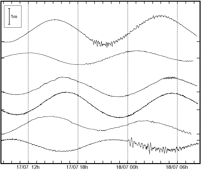
Figure 5: From top to bottom, the tidal curves of Bali, Cocos, Banda Aceh, Thailand, Seychelles and Rodrigues (Masahiro, Yamamoto, IOC via JMA).
These observations show that the tsunami amplitudes are low offshore. The first simulations performed by the CEA/DAM confirm maximum water elevation of about 50 cm in the ocean (Figures 6 and 7). The maximum energy, expected in the direction perpendicular to the subduction trench, effectively generated the highest amplitudes in the Pangandaran area (Figure 7).
Coastal amplifications may have resulted in water heights larger than 3 to 5 m, depending on local configurations. They could not yet be accurately estimated by simulation as detailed coastal data are required.
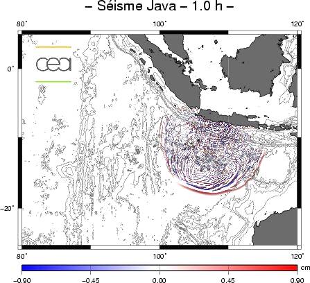
Figure 6: Ocean surface elevation one hour after the earthquake. The source parameters derive from the first seismological inversions. They correspond to a magnitude of 7.7, with a 130 km long and 30 km wide fault and a coseismic slip of 2.7 m (source: CEA/DAM).
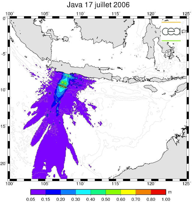
Figure 7: Maximum amplitudes calculated for the July 17, 2006 tsunami (source: CEA/DAM)
|
| |
|
|
|
)
)
)
)
)
)