 |
 |
 |
|
 |
|
|
|
Scientific files |
|
|
| |

|
Earthquakes on Sumatra (Indonesia), of magnitude Mw=7.6 on 30 September 2009
and Mw=6.8 on 1 October 1, 2009 |
 Description of the earthquake Description of the earthquake
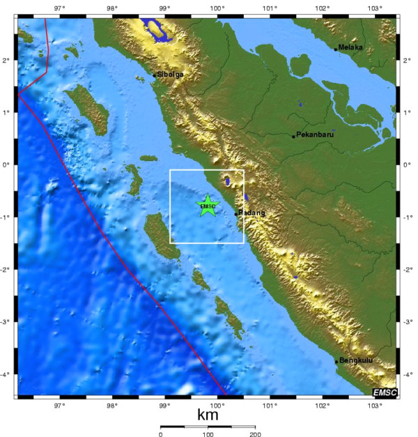
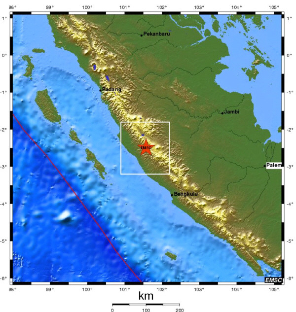
Two strong-magnitude earthquakes struck Sumatra, the first taking place on 30 September at 10h16 h UTC 60 km to the west of Padang, and the other on 1 October at 01h52 hr UTC 160 km to the North-West of Bengkula. These two earthquakes were very strongly felt over the whole of the central part of Sumatra. At the time of going to press (2 October 2009), estimates of damage and the numbers of victims are rather contradictory. According to news dispatches, there are reports of 500 to several thousand killed. This wide variation of estimates is probably due to the occurrence of two consecutive earthquakes in the same geographical area (Figure 1).
| Date |
30 september 2009 |
| Onset time |
10 h 16 mn 09 s TU |
| Latitude |
0,79° Sud |
| Longitude |
99,82° Est |
| Depth |
80 km |
| Magnitude |
7,6 (CEA/DASE, Mw estimated from P and SH waves) |
|
| Date |
1 October 2009 |
| Onset time |
01 h 52 mn 29 s TU |
| Latitude |
2,49° Sud |
| Longitude |
101,57° Est |
| Depth |
10 km |
| Magnitude |
6,8 (CEA/DASE, Mw estimated from P and SH waves) |
|
| Earthquake of 30 September 2009 |
Earthquake of 1 October 2009 |
|
|
 Figure 1: Map location of the two earthquakes (source: http://www.emsc-csem.org) Figure 1: Map location of the two earthquakes (source: http://www.emsc-csem.org)
Seismo-tectonic context
These two earthquakes, even if they are only separated by a distance of approximately 270 km, do not affect the same set of faults. The second earthquake is not an aftershock of the first one, and supplementary studies of the static stresses will be required to determine if they are linked.
The first earthquake (30 September 2009), of magnitude Mw=7.6, is the consequence of oblique convergence between the Australian and Sunda tectonic plates. At the level of the epicentre, the Australian plate is moving northward relative to the Sunda plate at a rate of approximately 65 mm/year. The relatively deep epicentre (80 km) and the focal mechanism obtained by inversion leads us to think that this earthquake took place within the Australian plate (intra-slab), and not at the interface between the two plates. Indeed, in the area of the epicentre, classical subduction earthquakes have epicentre depths of about 50 km.
The second earthquake (1 October 2009), of magnitude Mw=6.8, is close to the Great Sumatran Fault, which accommodates a northward component of the Sunda plate motion, being a consequence of oblique convergence. In the area of the epicentre of this earthquake, the Australian plate is moving towards the North-West relative to the Sunda plate, at approximately 65 mm/year.
A complete description of the seismo-tectonic context is available on the following website:
http://www.geologie.ens.fr/spiplabocnrs/spip.php?article306
Kinematic inversion (preliminary results)
This estimation involves reproducing seismic recordings at great distances from the epicentre by reconstructing the rupture history using the method of patches (Vallée M. and M. Bouchon: Imaging co-seismic rupture in far-field by slip patches, JGI, 2004). For this purpose, we reconstruct the displacements of the compressional (P) and shear (SH) body waves to achieve a better estimation of the seismic source.
Earthquake of 30 September 2009
The kinematic inversion using long-period data (CEA and IRIS) from seismic sensors yields a compressional-type focal mechanism with a slight strike-slip component, along with a magnitude of Mw=7.6 and a focal depth of 84 km. The length of the rupture is estimated at 80 km, with a maximum slip on this zone of about 2.5 m (Figure 2).
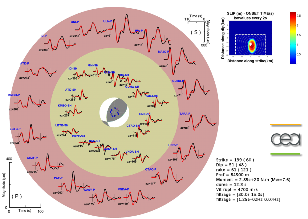
Figure 2: Inversion of the body waves (P and HS waves) leads to the determination of a slip zone and a magnitude of Mw=7.6. The rupture on the fault is at a depth of 84 km.
Earthquake of 1 October 2009
The kinematic inversion using long-period data (CEA and IRIS) from seismic sensors yields a strike-slip mechanism with a slight compressional component, a magnitude of Mw=6.8 and an epicentre depth of 14 km. The length of the rupture is estimated at 60 km, with a maximum slip on the fault of about 0.8 m (Figure 3).
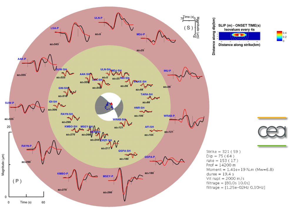
Figure 3: Inversion of the body waves (P and HS waves) leads to the determination of a slip zone and a magnitude of Mw=6.8. The rupture on the fault is at a depth of 14 km.
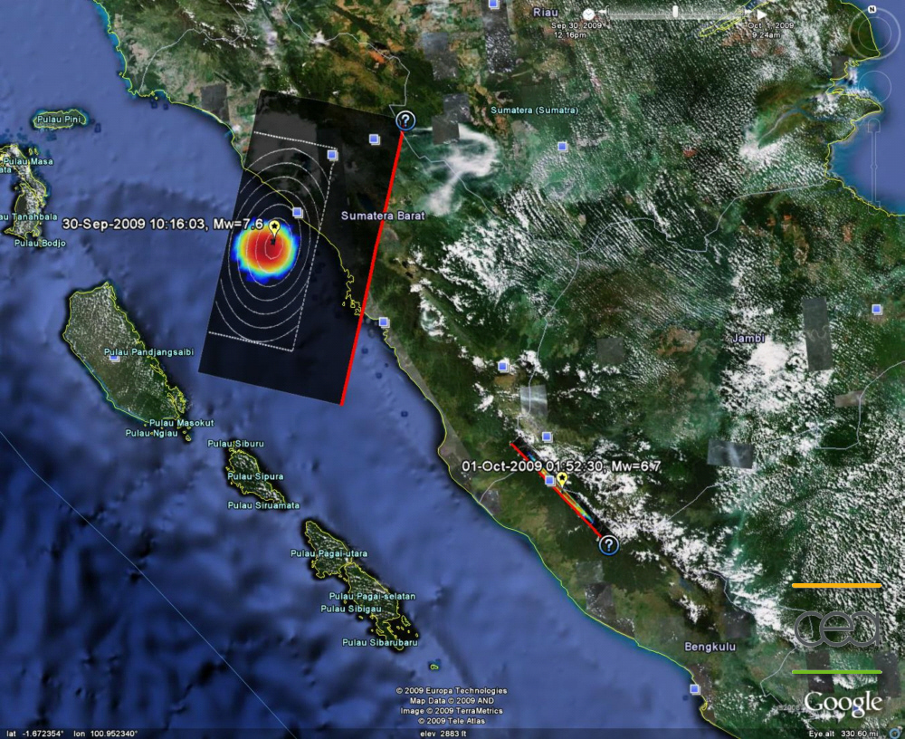
Figure 4: Map showing location of the two slip zones (multicoloured ellipse) and the fault planes (black rectangle) for the earthquakes of 30/09/09 and 01/10/09.
These are preliminary scientific results likely to be modified according to the input of new data and the choice of a different fault plane.
|
|
|
)
)
)
)
)