 |
 |
 |
|
 |
|
|
|
Scientific files |
|
|
| |

|
BRIEF NOTE concerning the Haiti earthquake on 12 January (Magnitude 7.2) |
A violent earthquake of magnitude Mw 7.2 occurred on 12 January 2010 at 21h53UTC near Port au Prince, the capital of Haiti. On Wednesday morning, the media were suggesting the risk of a death toll of hundreds or even thousands. Several ministries were seriously damaged, while hospitals, hotels and schools collapsed.
This earthquake is located at the boundary of the Caribbean and North American plates. Most of the seismicity accommodates an eastward lateral motion of approximately 20 mm/year of the Caribbean plate relative to the North American plate, taking place through strike-slip and compressive fault systems (the Septentrional Fault north of Haiti and the Enriquillo-Plaintain Garden fault zone in the south). The location and focal mechanism of the earthquake on 12 January are consistent with the Enriquillo-Plaintain Garden strike-slip fault system, which has not produced any destructive earthquakes for more than 150 years.
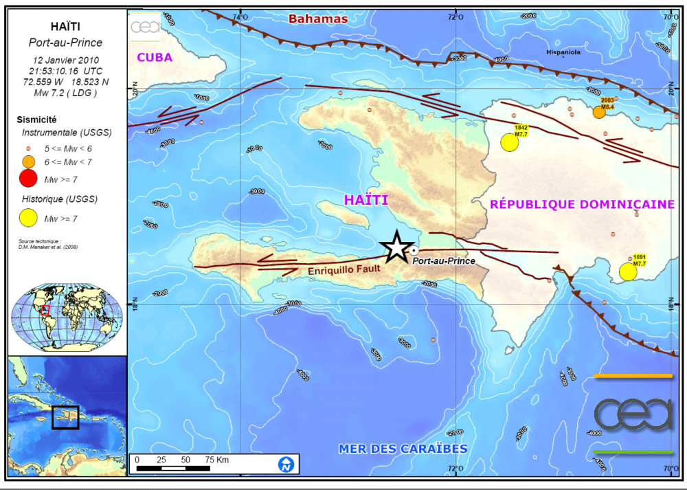
 Figure 1: Map of Haiti showing location of the epicentre (star) on the Enriquillo Fault. The yellow and orange filled circles indicate strong-magnitude historical earthquakes in the region. Figure 1: Map of Haiti showing location of the epicentre (star) on the Enriquillo Fault. The yellow and orange filled circles indicate strong-magnitude historical earthquakes in the region.
 Preliminary modelling of the seismic source Preliminary modelling of the seismic source
This estimation involves reproducing seismic recordings at great distances from the epicentre by reconstructing the rupture history using the method of patches (Vallée and Bouchon: Imaging co-seismic rupture in far-field by slip patches, JGI, 2004). For this purpose, we reconstruct the displacements of the compressional (P) and shear (HS) body waves to achieve a better forcing of the seismic source.
Based on the P and S body waves recorded on 14 broad-band stations at distances of 3 000 to 10 000 km from the earthquake, we can use inversion to determine the static characteristics of the seismic source (focal mechanism, depth and duration of the rupture), as well as certain kinematic parameters (amplitude of fault slip, rupture velocity).
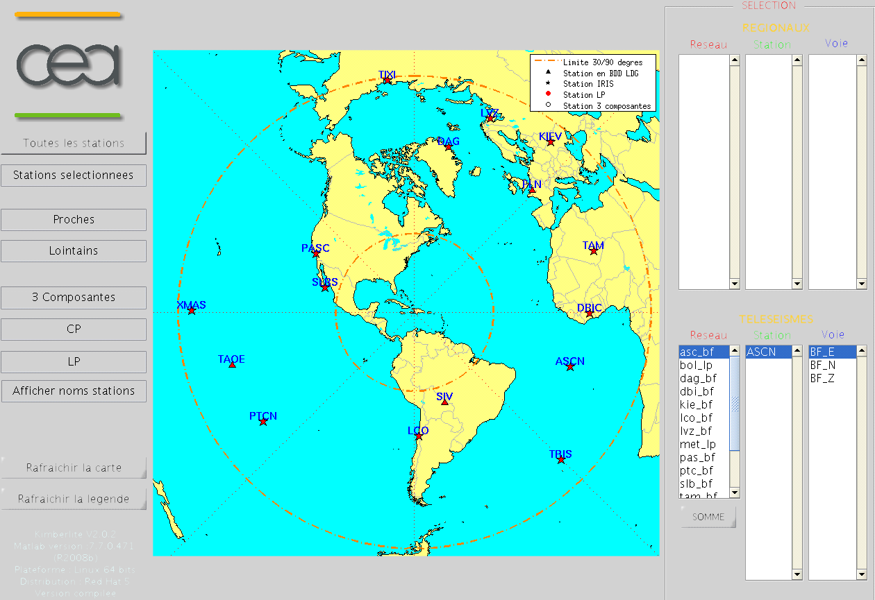
Figure 2: Screen capture showing location of the 13 IRIS stations and the 3 LDG broad-band stations of TAOE (Marquesas Islands) FLERS (France) and SIV (Bolivia) used for determination of the seismic source.
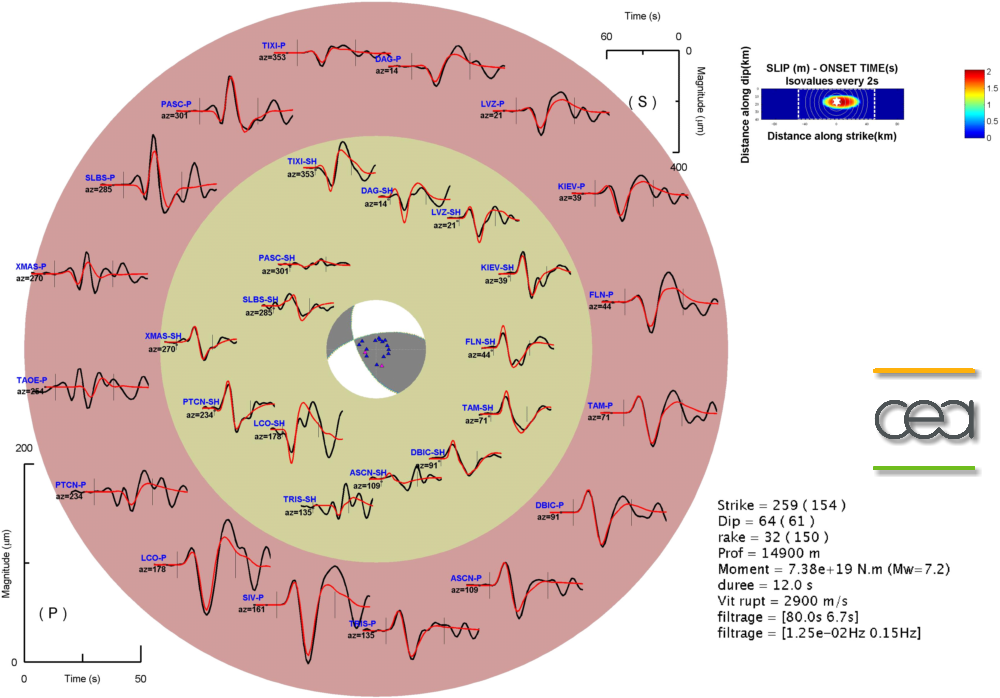
Figure 3: Rupture model and comparison of waveforms, with recorded signals (in black) and simulated signals (in red), using data filtered in the [80 s 6.7 s] band. Teleseismic SH waves are represented (in yellow inner circle) for a duration of 120 s, and teleseismic P waves (in red outer circle) for a duration of 60 s. The elliptical distribution of slip obtained by the method of patches is indicated on the right of the diagram.
The geometrical parameters obtained are coherent with regional tectonics; the strike, dip and slip of the fault (259°, 64° and 32°, respectively) indicate a strike-slip earthquake related to movement between the Caribbean and North American plates, with moreover a slight compressive component.
The depth of the earthquake is estimated at 15 km and the amplitude of the maximum slip on the fault is about 2 m.
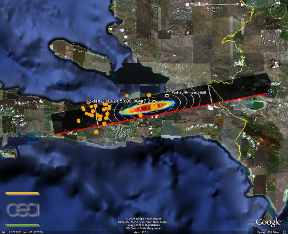
Figure 4: Distribution of slip and position of aftershocks with magnitude greater than 4.5 (USGS). |
|
|
)
)
)
)