 |
 |
 |
|
 |
|
|
|
scientific files |
|
|
| |

|
Earthquake in the Western Mediterranean
on 7 July 2011
|
An earthquake of magnitude of 5.3 occurred in the Western Mediterranean on 7 July 2011 at 19h21 UT (21h21 French local time), approximately 95 km offshore from the town of Ajaccio. The maximum intensity was IV (MSK) in Corsica and on the Riviera (www.franceseisme.fr).
It was followed by some aftershocks, the most important of which, showing a magnitude of 3.6, occurred 17 minutes after the main shock. It was preceded by a smaller earthquake of magnitude 4.0 that took place on 2 July 2011 at 14h43 UT. The main shock of 7 July 2011was felt throughout Corsica, where 1200 calls were made to the fire services. This earthquake is the strongest known event occurring to the west of Corsica since 1775 (seismic event with a maximum intensity of VII MSK). This region is subject to regular seismic activity which is concentrated a little farther north in the area of the Ligurian Sea. The Imperia earthquake of 1887, with an epicentral intensity of IX (MSK), was one of the most destructive historical events having an impact within French territory. More recently, on Friday 19 July 1963, a magnitude-5.9 earthquake occurred in the western Ligurian Sea, representing the strongest earthquake recorded in France by a seismograph network.
 Seismo-tectonic context Seismo-tectonic context
Over geological time, between 35 and 20 million years ago, Corsica has undergone an anti-clockwise rotation accompanied by the opening of the Ligurian-Provençal Basin. At the present day, a generalized collision can be observed between Africa and Europe. The Ligurian margin is subjected to a NW-SE compressional stress regime which generates the seismicity. The most important seismic events recorded in the historical and instrumental data bases (see figure below) are located in the west of the Gulf of Genoa. This compressional regime is consistent with the analysis of the seismic signals, which show that the earthquake of 7 July 2011 took place on a reverse fault striking SW-NE.
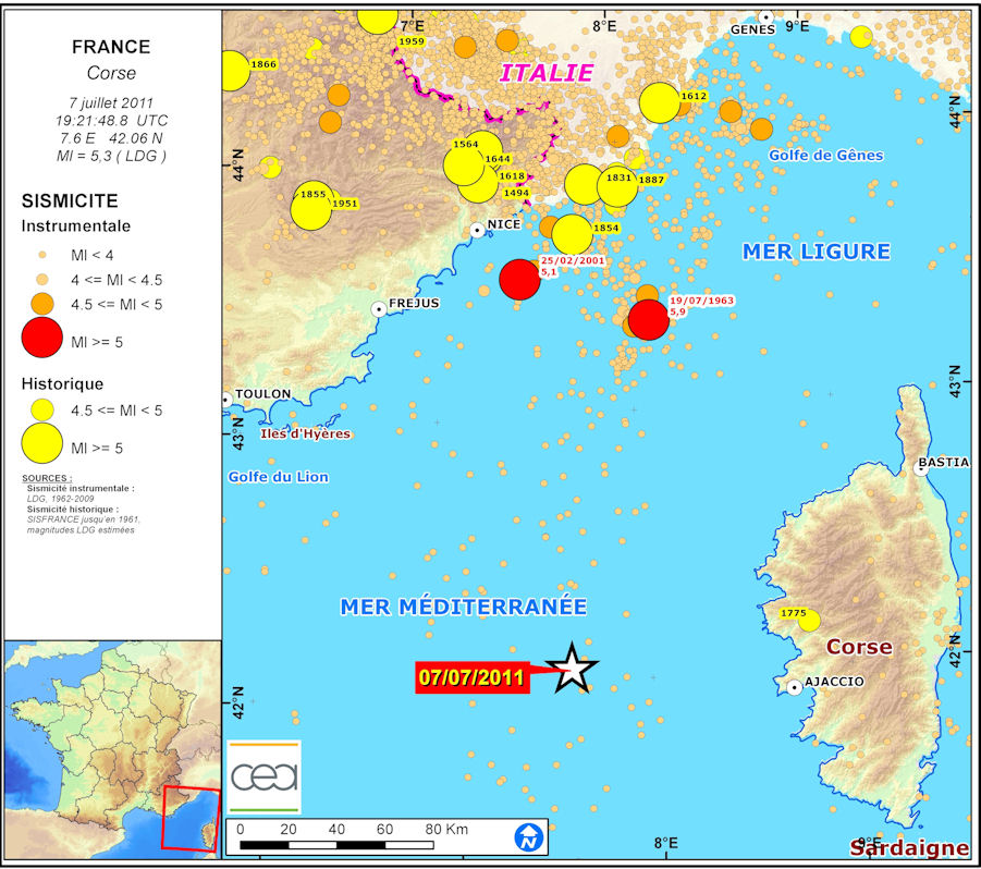
 Figure 1: Map showing location of the earthquake. Figure 1: Map showing location of the earthquake.
Analysis of seismic source.
The source parameters were obtained based on the first movements of the P wave measured at the CEA-DASE and IRIS stations. The inversion using these data yields a reverse -fault mechanism with a fault plane striking SW-NE. The source is located at a depth of 12 km. The depth estimate is corroborated by the observation of PPP and sP phases at teleseismic distances. The seismic moment is 6.06E+16 Nm (Magnitude Mw=5.1).
These are preliminary scientific results which are likely to be modified according to the input of new data and the choice of a different fault plane.
| Azimuth |
217° (56°) |
| Dip |
33° (58°) |
| Slip |
74° (100°) |
| Depth |
12.3 km |
| Seismic moment |
6.06E+16 Nm (Mw 5.1)
|
|
Seismic source parameters of the 7 July 201 earthquake.
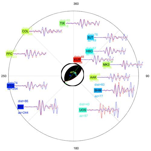
Figure 2: real signals (red) and synthetic signals (blue) obtained for the earthquake of 7 July 2011. (CEA-DASE and IRIS stations).
|
| |
|
|
|
)
)