 |
 |
 |
|
 |
|
|
|
scientific files |
|
|
| |

|
Magnitude 4.3 earthquake in the south of Ardèche
03/08/2011
|
On 3 August 2011 at 01h36min UT, the Detection and Geophysics Laboratory located an earthquake of magnitude 4.3 with an epicentre located in the south of the department of Ardèche. The maximum intensity of this earthquake is estimated at IV (www.franceseisme.fr). This seismic event occurred near the Cevennes Fault. It is the largest earthquake recorded in this sector since the network of observation stations was set up in 1962. Historically, no earthquake of notable intensity (i.e. epicentral intensity higher than V) has been reported in the Cévennes. At the level of the Cévennes fault bundle, which runs from the Eastern Pyrenees to the Rhone valley, some weaker earthquakes have been localized by our network (ML<3.4) in the sectors of Aubenas and Pont dArc. To the east of the Rhone, the area around Tricastin has been the seat of several seismic crises. The majority of these crises lasted several months and included several tens of events that were actually felt (06/1772 to 02/1773, 06/1872 to 12/1872, 07/1873 to 01/1875, 10/1933 to 12/1934 and 10/1935 to 08/1936). The strongest events of these crises reached epicentral intensities of VII-VIII. A little farther south towards Caderousse, an event took place on 24/09/1924 which reached an epicentral intensity of VI-VII.
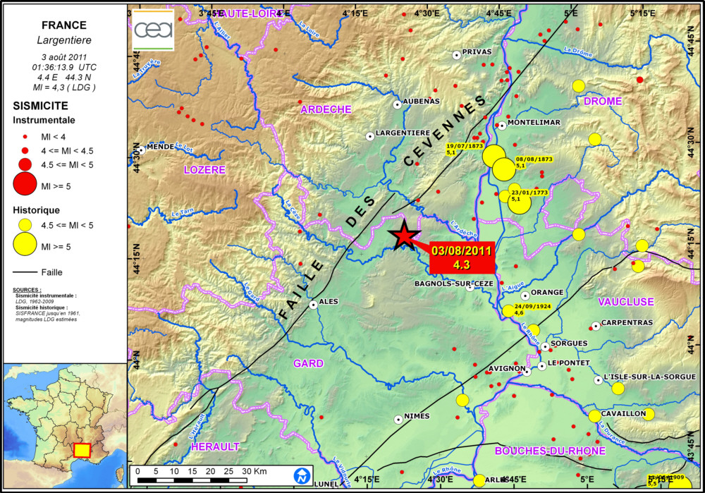
 Map showing location of the earthquake and seismicity of the region. Map showing location of the earthquake and seismicity of the region.
 Seismic sequence Seismic sequence
The earthquake was preceded by 2 minor events of magnitude 1.7 and 1.6. Fourteen aftershocks, of magnitude ranging between 1.5 and 2.3, were then detected during the hours following the main shock. All the events of the seismic sequence are located within a radius of less than 3 km, to the east of the town of Barjac.
Date & Time |
Lat. |
Lon. |
Depth (km) |
Mag. (Ml) |
03/08/2011 00:45:16 |
44.29 |
4.41 |
4.0 |
1.7 |
03/08/2011 01:01:07 |
44.28 |
4.40 |
4.0 |
1.6 |
03/08/2011 01:36:13 |
44.30 |
4.40 |
4.0 |
4.3 |
03/08/2011 01:46:24 |
44.30 |
4.40 |
4.0 |
1.7 |
03/08/2011 01:46:59 |
44.28 |
4.40 |
4.0 |
2.0 |
03/08/2011 01:47:29 |
44.28 |
4.41 |
3.0 |
2.3 |
03/08/2011 01:49:05 |
44.29 |
4.39 |
4.0 |
1.8 |
03/08/2011 02:12:45 |
44.29 |
4.39 |
7.0 |
1.7 |
03/08/2011 02:12:48 |
44.29 |
4.40 |
2.0 |
1.5 |
03/08/2011 02:28:09 |
44.28 |
4.39 |
4.0 |
2.2 |
03/08/2011 03:11:57 |
44.30 |
4.39 |
5.0 |
2.2 |
03/08/2011 03:22:30 |
44.28 |
4.40 |
6.0 |
1.9 |
03/08/2011 03:46:47 |
44.30 |
4.41 |
3.0 |
2.0 |
03/08/2011 05:19:53 |
44.29 |
4.40 |
7.0 |
2.3 |
03/08/2011 05:27:59 |
44.29 |
4.40 |
2.0 |
2.1 |
03/08/2011 05:44:30 |
44.29 |
4.39 |
6.0 |
2.2 |
03/08/2011 08:37:52 |
44.28 |
4.41 |
2.0 |
1.6 |
List of earthquakes associated with the event at Largentière on 3 August 2011.
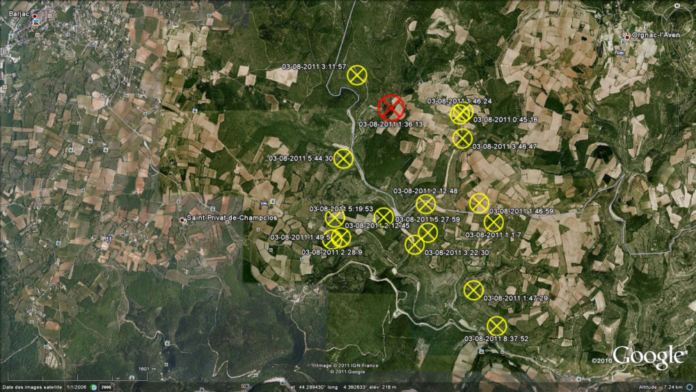
Location map of earthquakes associated with the event at Largentière on 3 August 2011.
|
|
|
)
)