 |
 |
 |
|
 |
|
|
|
scientific files |
|
|
| |

|
Earthquake of magnitude 4.8 north of Barcelonnette
on 26 February 2012 |
On 26 February 2012 at 22h37 UT, the Detection and Geophysics Laboratory (LDG) located an earthquake of magnitude 4.8 with an epicentre located 15 km north of Barcelonnette (Alpes de Haute-Provence). This seismic event occurred in the Embrunnais-Ubaye Massif, in an area affected regularly by moderate seismicity (Figure 1). Its epicentre is close to that of the earthquake of 05/04/1959, which had an epicentral intensity of VII-VIII and a magnitude M=5.3, representing the strongest earthquake ever recorded in the southern French Alps.
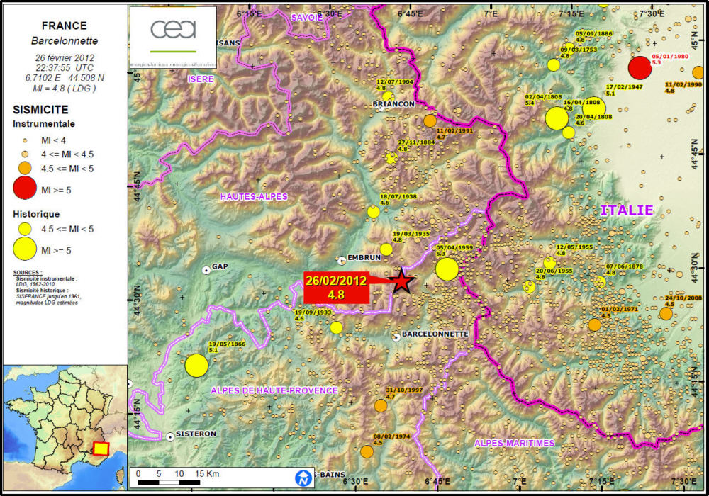
 Figure 1: Location of the event on 26 February 2012 at 22h37 UT (red star), as well as historical (yellow circles) and instrumental seismicity contained in the LDG database. Figure 1: Location of the event on 26 February 2012 at 22h37 UT (red star), as well as historical (yellow circles) and instrumental seismicity contained in the LDG database.
 Seismo-tectonic analysis Seismo-tectonic analysis
The focal mechanism of the event of 26/02/2012 (Figure 3) is very similar to that of the 1959 earthquake (Figure 2) and agrees with slip on a normal fault striking NW-SE (dipping 65° towards the west) with a small dextral strike-slip component, or its conjugate fault striking NE-SW with a weaker dip towards the east.
While these two fault directions are present in the Ubaye Massif (e.g. Sue et al., 2007), the NW-SE trend (N130 to 160) is nevertheless more marked (Figure 2). It should be noted that some of the faults near the earthquake are suspected to have been active during the Quaternary (e.g. the Serenne Fault or the Font Sancte Fault, a conjugate fault of Sue et al., 2007, see figure 2).
Some of these faults are the seat of dense seismic swarms and have developed over relatively long intervals of time. The best studied and nearest of these swarms (more than 16,000 small earthquakes located over the period 2003-2004 by Jenatton et al., 2007) developed over a length of 9 km at depths ranging between 3 and 8 km, which is close to the depth estimated for the earthquake of 26/02/2012. The swarm shows a NW-SE orientation on a westward dipping plane very similar to plane 1 of the focal mechanism (Figure 2).
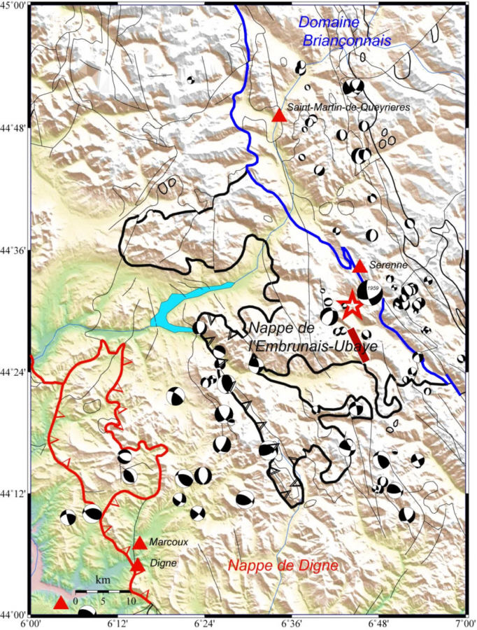
Figure 2: Tectonic sketch map of the area affected by the earthquake of 26/02/2012. Location of earthquake epicentre (red star) determined by LDG. The black, red and blue solid lines represent faults taken from the 1:1,000,000 geological map of France (BRGM). The red triangles indicate sites where neotectonic activity has been reported (source: Neopal 2012; Sweat et al., 2007). The black and white circles represent a geometric synthesis of data characterizing slip planes associated with the strongest instrumental earthquakes in the area (focal mechanisms), their diameter being proportional to the magnitude of the event. The sources of the focal mechanisms are primarily derived from studies on data of the SISMALP and LDG networks. The brown rectangle indicates the areal extent of the seismic swarm, where 16,000 events took place from 2003-2004 (Jenatton et al., 2007).
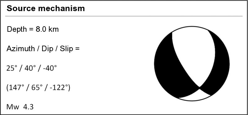
Analysis of the seismic source
Inversion of the moment tensor allows us to determine the strike of the fault that has ruptured, as well as the moment magnitude Mw. In the case of the Barcelonnette earthquake, the moment tensor was determined by searching for a similarity between the simulated and the observed signals (for distances between 43 km and 596 km). The signals were filtered in the band-width [0.03 0.1] Hz.
The depth of 8 km is constrained by the presence of deep seismic phases (PPP and sP) on stations at teleseismic distances.
The results of the inversion yield a normal fault mechanism characteristic of an extensional regime, associated with a weak dextral strike-slip component.
![Signaux sismiques synthétiques (en bleu) et observés (en vert) du séisme de Barcelonnette sur les composantes verticale, radiale et transversale (bande passante [0,03 0,1]Hz)](images/ondes_sismiques.png)
Figure 3: Synthetic (blue) and observed (green) seismic signals obtained from the Barcelonnette earthquake on the vertical, radial and transverse components (band-width [0.03 0.1] Hz).
Seismic sequence
The earthquake was preceded by 3 minor events of magnitude ML ranging between 1.0 and 1.5, occurring on 24 February and 26 February in the morning. The main shock was thus the forerunner of a sustained seismic sequence. As of 2 March, the CEA/DASE recorded 57 aftershocks, including 3 with magnitudes greater than 3.5, which thus led to the issuing of an earthquake alert to the authorities (see Table below). The seismic swarm is located 10 km north of the town of Barcelonnette, and extends over an area no more than 7 km in length.
Date & time |
Lat. |
Long. |
Depth (km) |
Mag. (ML) |
26/02/2012 22:37:55 |
44.508 |
6.7102 |
7.0 |
4.8 |
26/02/2012 23:39:34 |
44.509 |
6.693 |
7.0 |
3.7 |
27/02/2012 16:31:21 |
44.468 |
6.662 |
10.0 |
4.0 |
02/03/2012 07:15:51 |
44.481 |
6.740 |
10.0 |
4.1 |
Table: List of seismic events of magnitude ML > 3.5 associated with the Barcelonnette earthquake of 26 February 2012.
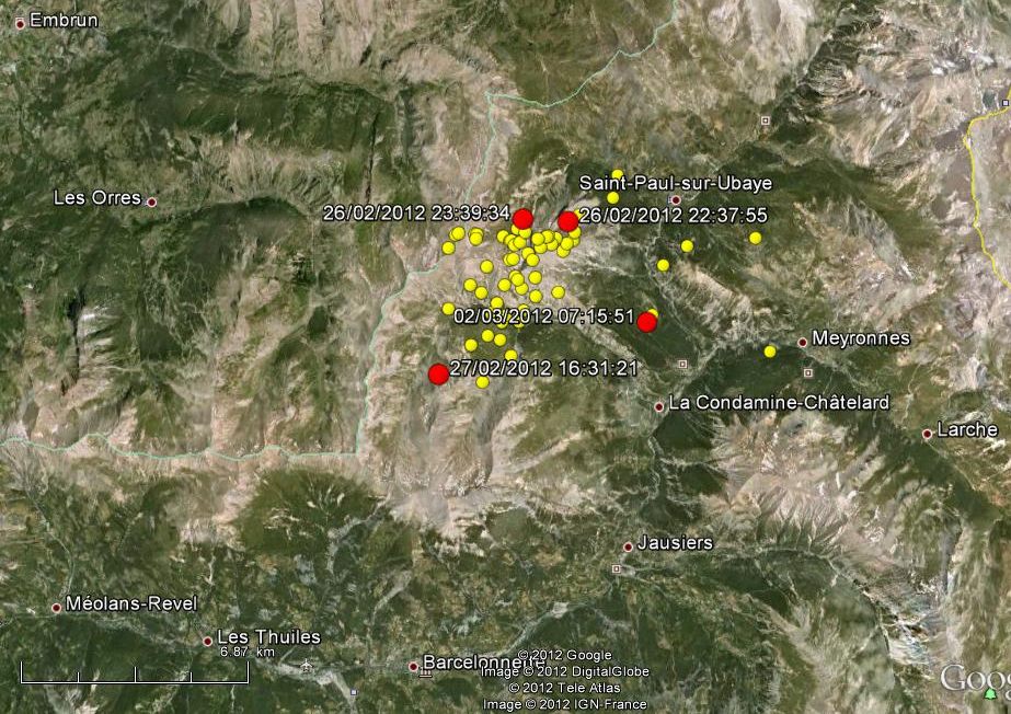
Figure 4: Location map of earthquakes associated with the Barcelonnette event of 26 February 2012. Events of magnitude ML>3.5 are represented by red circles, and events of ML<3.5 by yellow circles.
|
|
REFERENCES: |
|
|
| |
|
| |
|
|
|
)
)
)