 |
 |
 |
|
 |
|
|
|
scientific files |
|
|
| |

|
Eruption of Bezymianny volcano (Russia) on 01/09/2012 monitored by infrasound measuring stations
|
 Summary Summary
Bezymianny volcano erupted on 1 September 2012 at 19h16 UT, leading to large pyroclastic flows. The resulting ash plumes, reaching an altitude of up to 12 km, could be observed on spectacular satellite images obtained by the Tokyo VAAC (Volcanic Ash Advisory Center). This intense explosive phase persisted until 19h45 UT, and was followed by a long tremor with a duration of 2 h.
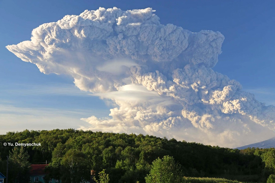
 Photograph 1: Bezymianny, eruption of 01-09-2012.
Source: Yu. DEmyanchuk/KVERT (Kamchatkan and Northern Kuriles Volcanic Activity). Photograph 1: Bezymianny, eruption of 01-09-2012.
Source: Yu. DEmyanchuk/KVERT (Kamchatkan and Northern Kuriles Volcanic Activity).
The next day, ash emissions continued and the plume extended over a distance of 1500 km to the East of Bezymianny (photographs TERRA/MODIS). The KVERT (Kamchatka Volcanic Eruption Response TEAM) indicated that, on 3 September, seismic activity had returned to normal, with a resumption of the extrusion of viscous lavas leading to the formation of a new thick flow.

Photograph 2: Bezymianny, extent of the ash cloud on 02-09-2012, according to a MODIS image (2 km resolution) from NASA’s Terra satellite.
This intense eruptive activity was detected by five infrasound stations forming part of the worldwide IMS network (International Monitoring System). The signals of the eruption were recorded at distances of up to approximately 5 000 km from the volcano:
- Station I44RU in Russia, 370 km from the volcano.
- Station I30JP in Japan, 2765 km from the volcano.
- Station I53US in Alaska, to 2915 km from the volcano.
- Station I34 MN in Mongolia, to 3740 km, from the volcano.
- Station I18DK in Greenland, 4810 km from the volcano.
Figure 1 shows the location of these stations with respect to the volcano.
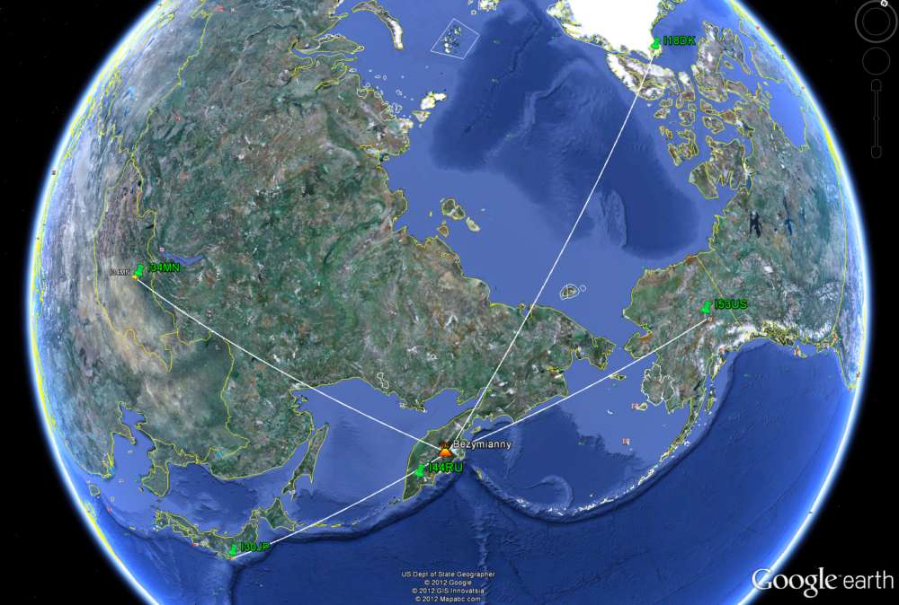
Figure 1: Location of infrasound stations (green pins) detecting the eruptions of the Bezymianny volcano.
Description of the volcano
The Russian volcano Bezymianny (Lat. 55.98°N, Long 160.6°E) is a stratovolcano belonging to a group of highly active volcanoes including Shiveluch and Kliuchevskoi. It is located in the northern part of the Kamchatka peninsula. Formerly considered as extinct, Bezymianny started a new eruptive phase in 1955, characterized by violent eruptions accompanied by extensive ash plumes reaching altitudes of 8-15 km.
Processing of infrasound data
Figure 2 shows an example of a time/frequency diagram. The results are calculated from weekly automatic bulletins based on a continuous recording from the Russian station I44RU, by applying the Progressive Multi-Channel Correlation algorithm (Cansi, 1995). Each black band corresponds to a single day, with the X-coordinate representing the time from 0 to 24h UTC, and the Y-coordinate the frequency from 0 to 4 Hz. The coloured rectangles represent automatically detected events, whose azimuth (0-360°, direction of arrival of the wave at the station with respect to north) is indicated on the scale on the right-hand side of the figure.
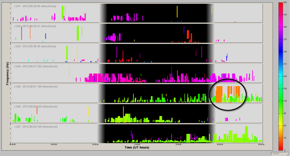
Figure 2: Stack of automatic PMCC bulletins from the I44RU infrasound station in Russia, from 28 August to 3 September. The dashed-dotted circle indicates detected signals associated with the volcano.
Detected events in orange correspond to the recording of infrasound waves generated by the Bezymianny volcano during its eruption on 1 September 2012. Their frequencies range between 0.5 and 3 Hz.
In more detail, Figure 3 shows a blow-up of the detected signals observed on Figure 2. The top of the figure corresponds to the recorded signal (in Pa) as a function of time. The associated PMCC-detected signals are shown at the bottom of the figure.
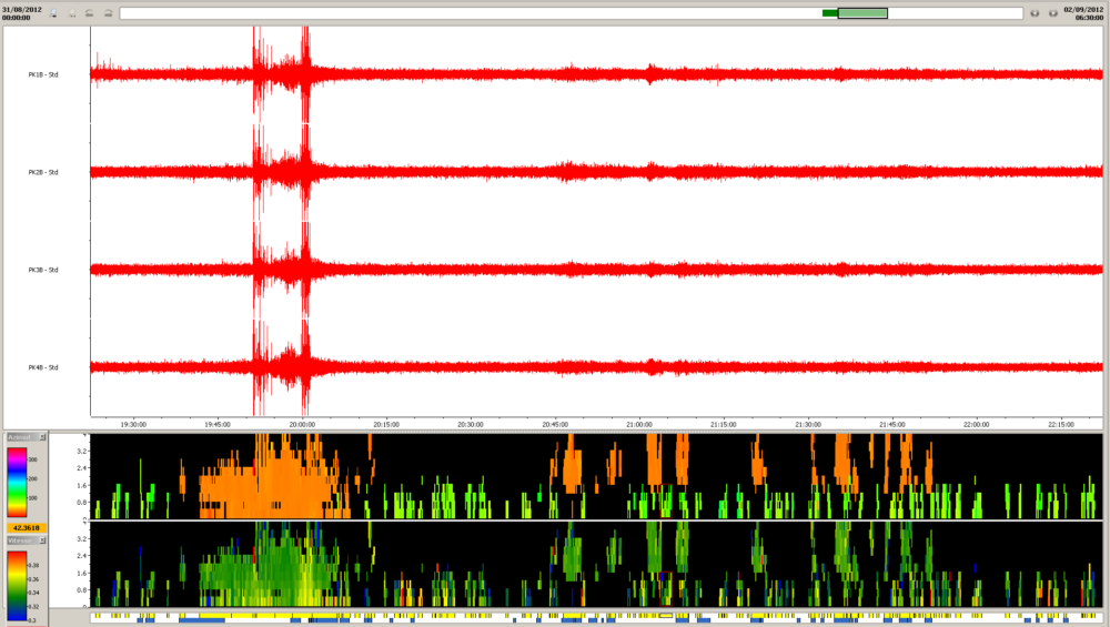
Figure 3: Representation of signals and automatically detected events (orange) associated with eruption of Bezymianny volcano, recorded at Russian station I44RU on 1 September 2012.
The recordings contain two types of signals: initially, pulses/?bursts were recorded corresponding to the intense eruptive phase of Bezymianny, followed by a more continuous high-frequency signal, which could coincide with explosions of lower intensity.
Using the set of infrasound signals detected at the various stations, while not taking into account the effect of upper-level winds on propagation, it is possible to obtain an estimate of the localization of the event by crossing of azimuths. For that purpose, we only consider the highest energy part of the signals, corresponding to the intense eruptive phase recorded at all the stations. The localization so calculated is approximately 110 km away from the true position. The simulation of wave propagation would make it possible to integrate the effects of upper-level winds and appreciably reduce this discrepancy.
Potential of infrasound for volcanic monitoring
Infrasound measuring stations currently represent an effective means of improving the monitoring of volcanoes. The coverage of the network is such that it enables us to obtain useful information on volcanic activity at a global scale. More detailed studies would make it possible to quantify the effects of various atmospheric phenomena, such as the wind, on the propagation of infrasound waves, and thus improve the capacity of detection as well as localization of the source. The major issue at stake in these studies is the optimization of an infrasound network, as a supplement to other observation systems (seismic, satellites, etc.), for the remote monitoring of dangerous volcanoes that are poorly instrumented (Matoza et al., 2009). The array put in place will need to take account of the daily and seasonal variability in performance of the network as well as the travel times of waves from the source to the various stations.
|
|
Sources |
|
|
| |
|
| |
|
|
|
)
)