 |
 |
 |
|
 |
|
|
|
Scientifiques files |
|
|
| |

|
Earthquake in the area of Lourdes on 30 December 2012 |
An earthquake of magnitude 4.8 took place to the west of Lourdes at 0h35 local time on 31 December 2012 (corresponding to 23h35 universal time or GMT, 30/12/2012). It was preceded and followed by several moderate shocks, the strongest of which were felt by the population.
 Location of the main shock
The main shock attained a local magnitude of 4.8 (seismic moment magnitude = 4.2). It occurred on December 31 at 00h35 standard time (i.e. 30/12/2012 at 23h35 GMT); the focus was located at latitude 43.11°N and longitude 0.21°W (Figure 1), 10 km to the west of Lourdes, at a depth of 6-10 km.
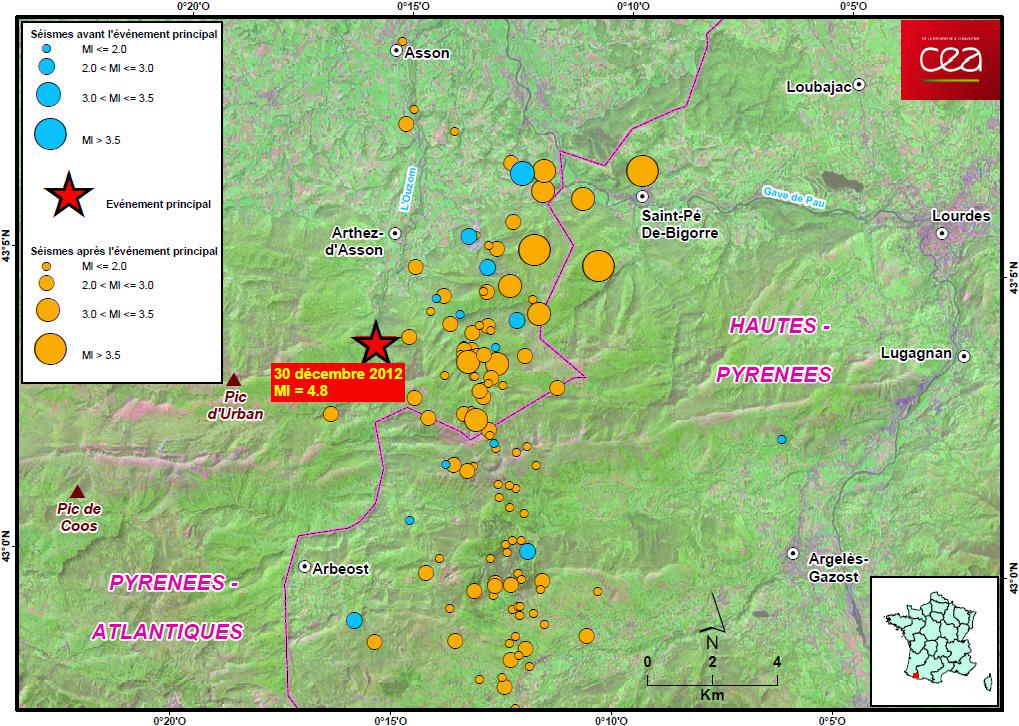
 Figure 1. Location of the main shock and weaker precursor events (from 12 to 30 December 2012; shown as blue circles) and aftershocks (from 31 December to 10 January 2013; shown as orange circles).
The earthquake took place in the department of the Pyrénées-Atlantiques near the border with Hautes-Pyrénées (Figure 2). This zone of the Western Pyrenees is the most seismically active in Metropolitan France in terms of frequency of events. On average, four seismic events of ML > 4.5 are observed in this zone per decade, whereas, in the eastern part of the chain, less than one event is observed over the same period.
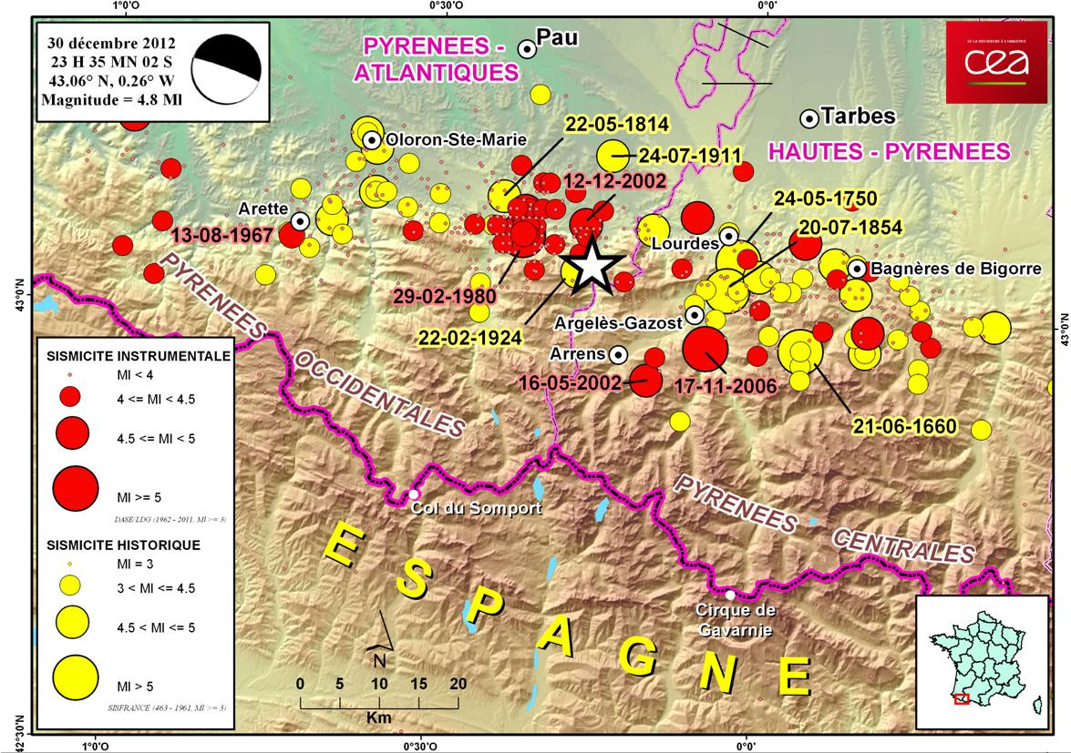
Figure 2. Location of the earthquake on 30/12/12 (white star) and main historical earthquakes in the region.
Some notable historical earthquakes in this zone:
|
Name |
Date |
Max. intensity (MSK) |
Magnitude * |
|
Central Pyrenees, Bigorre |
21/06/1660 |
VIII-IX |
5.9 |
|
Central Pyrenees, Juncalas |
24/05/1750 |
VIII |
5.5 |
|
Western Pyrenees, Ossau Valley |
22/05/1814 |
VII |
5.1 |
|
Central Pyrenees, Argeles Gazost |
20/07/1854 |
VII-VIII |
5.3 |
|
Western Pyrenees, Ossau Valley |
22/02/1924 |
VII |
4.9 |
|
Western Pyrenees, Arette |
13/08//1967 |
VIII |
5.3 |
|
Western Pyrenees, Ossau-Arudy Valley |
29/02/1980 |
VII-VIII |
5.7 |
|
Western Pyrenees, Argelés Gazost |
17/11/2006 |
VI |
5.4 |
|
Western Pyrenees, area of Lourdes |
30/12/2012 |
V |
4.8 |
|
Table 1. Main earthquakes of the Western and Central Pyrenees.
(*) = Main earthquakes of the Western and Central Pyrenees. (*) = local Magnitude ML given by LDG for events after 1962, and magnitude estimated from macroseismic intensities for the earlier events.
Characterization of the source of the main shock
Inversion of the moment tensor allows us to determine the strike of the fault that has ruptured, as well as the moment magnitude Mw. In the case of the Lourdes earthquake, the moment tensor was determined by searching for a similarity between the simulated and the observed signals (for distances between 15 km and 450 km, stations shown on Figure 3).
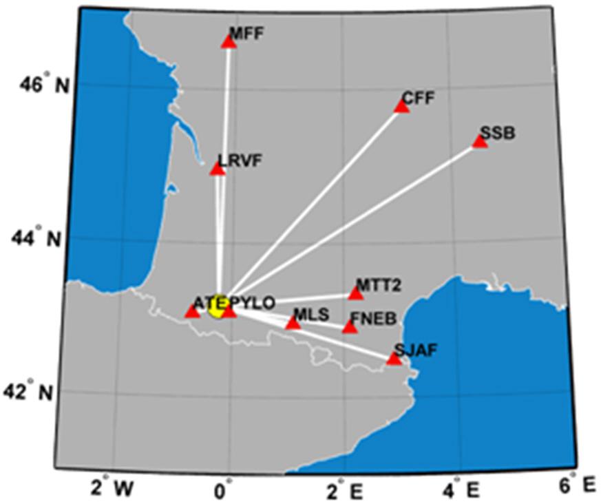
Figure 3. Seismic stations used to determine the seismic moment tensor of the earthquake
The signals of the stations located at less than 50 km from the source (ATE, PYLO) were assigned a null weighting in the inversion algorithm, to avoid overlaps in time of the P, S and surface-wave phases. The signals were filtered in the band-width [50 – 20] s.
The results of the inversion yield a normal fault mechanism characteristic of an extensional regime, with an azimuth of 290 ° (Figure 4), an epicentral depth of 6 km and a magnitude of MW = 4.2.
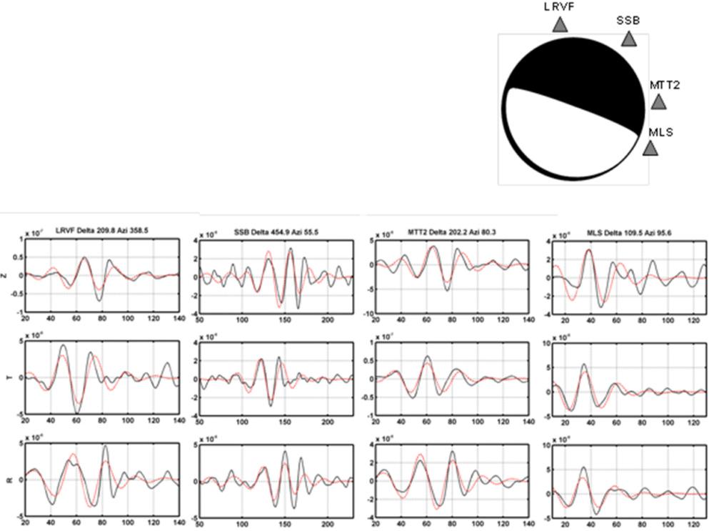
Figure 4. Focal mechanism and depth determined from inversion of wave forms of the seismic signals
|
Source parameters |
|
|
Depth |
6 km |
|
Azimuth |
290° |
|
Dip |
85° |
|
Slip |
-93° |
|
Mw |
4.2 |
|
Other organizations have published similar and more precise mechanisms based on the use of a dense network of seismic stations in the Pyrenees (see the OMP website concerning this event)
Seismo-tectonic context
The Pyrenees form a mountain chain at the border between France and Spain. The main geological and tectonic evolution of this chain dates back to the Triassic, at the beginning of the Mesozoic.
We currently distinguish several zones in the Pyrenees, going from north to south (Figure 5):
- The North-Pyrenean Zone, which is bounded to the north by the North Pyrenean Thrust Front (CFNP).
- The Axial Zone is characterized by the presence of the highest peaks of the chain, and is made up of structures affected by the Hercynian and Alpine orogenies. It is bounded to the north by the North-Pyrenean Fault.
- The South-Pyrenean Zone, which is bounded to the south by the South-Pyrenean Thrust (CSP).
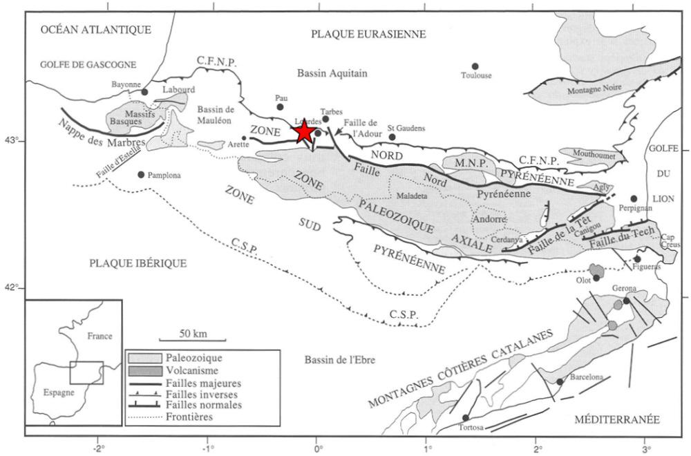
Figure 5. Structural sketch map of the Pyrenean orogenic belt in France. (Mattauer and Henry, 1974). Red star: location of the epicentre of the earthquake of 30 December 2012.
The North-Pyrenean Fault (Figure 5) is a major tectonic feature which extends from west to east over the entire length of the chain, and which is regarded as having played an important role in the geodynamic evolution of the Pyrenees (Choukroune and Mattauer, 1978). The North-Pyrenean Fault is regarded as a plate boundary between Eurasia and Iberia, which acted as a transform fault during the opening of the Bay of Biscay between 115 and 80 Ma ago, being more or less deformed by the collision (Roure and Choukroune, 1989). The general tectonic stress regime accounting for the current seismicity of the Pyrenees is a roughly North-South compression (Delouis et al., 1993), with the Iberian domain being thrust under Eurasia towards the north, at least in the central and eastern parts of the chain (Souriau and Granet, 1995).
This faulted western part of the North Pyrenean Zone displays a very strong density of small seismic events, with several destructive earthquakes of magnitude > 5 occurring since the 18th century (Table 1). The depth of most of the earthquakes seems to vary between 5 and 12 km.
The epicentral zone is located near the North Pyrenean Fault, which is itself poorly expressed in this area, and lies within the clearly marked E-W zone of seismicity extending from the Adour Fault in the west to beyond Arette in the east. Preliminary results yield a focal mechanism as a normal fault, but this needs to be refined in forthcoming studies.
Perceived seismic intensity in the Lourdes area and site effects
The earthquake of 30/12/2012 took place near the town of Lourdes. This town was partially destroyed by earthquakes in 1660 (Bagnères de Bigorre, intensity IX, about 20 km from Lourdes) and in 1750 (Juncalas, intensity VII, only 5 km from Lourdes). Many reports were referenced by the BCSF (French Seismological Central Office), not only for the main shock of 30 December 2012, but also concerning its different aftershocks. A study of this collection of reports (see site of the French Seismological Central Office) will allow a precise determination of the intensity charts and a better understanding of the seismic site effects that are regularly observed in the area around Lourdes. These effects can lead to an amplification of ground acceleration by a factor of up to 10 in sedimentary zones compared to zones with rock substratum (Dubos and Al, 2003).
P. Choukroune, M. Mattauer, 1978. Tectonique des plaques et Pyrénées : sur le fonctionnement de la faille transformante nord-pyrénéenne ; comparaison avec des modèles actuels. Bulletin de la Société Géologique de France, ser. 5, 20, 689-700.
B. Delouis, H. Haessler, H. Cisternas, L. Rivera, 1993. Stress tensor determination in France and neighbouring regions. Tectonophysics, 221, 413-437.
N. Dubos, A. Souriau, C. Ponsolles, J.F. Fels et Sénéchal, 2003. Etudes des effets de sites dans la ville de Lourdes (Pyrénées France) par la méthode des rapports spectraux. Bull. Soc. Géol. Fr., 174, 33-44.
M. Mattauer et J. Henry, 1974. The Pyrenees. In: Mesozoïc-Cenozoïc Orogenic Belts. Data for orogenic Studies: Alpine-Himalayan Orogens (Ed.A.M.Spencer), Spec.Publ.Geol.Soc.London, 4, 3-21.
F. Roure, P. Choukroune, X. Berastegui, J.A. Munoz, A. Villien, P. Matheron, M. Baryet, M. Seguret, P. Camara, J. Deramond, 1989. ECORS deep seismic data and balanced cross sections : geometric constraints on the evolutions of the Pyrenees. Tectonics, 8(1), 41-50.
A. Souriau, M. Granet, 1995. A tomographic study of the lithosphere beneath the Pyrenees from local and teleseismic data, J. Geophys. Res., 100, 18 117-18 134.
|
|
|
)
)
)
)
)