 |
 |
 |
|
 |
|
|
|
Scientifiques files |
|
|
| |

|
Earthquake of magnitude 7.7 in the area of Arawan (Pakistan) on 24 September 2013 |
A 7.7-magnitude earthquake occurred on 24 September 2013 in Balochistan (Pakistan) in the area of Arawan, in the north-eastern Makran range.
 Seismo-tectonic context
This mountain range results from the subduction of the Arabian plate. Its eastern margin is affected/deformed by a series of active sinistral strike-slip faults trending N-S to NE–SW, which accommodate more than half of the 4 cm/year of convergence between the Indian plate and Eurasia. The earthquake of 24 September 2013 was caused by movement on one of these faults running parallel to the axes of the large folds in the Makran range.
This active fault system connects up towards the north with the major faults of Shaman and Ghazaband-Quetta. On 25 May 1935, this latter fault produced an earthquake of similar magnitude (M=7.5), whose rupture affected the town of Quetta, in the immediate vicinity of the fault, leading to a death toll of more 15,000.
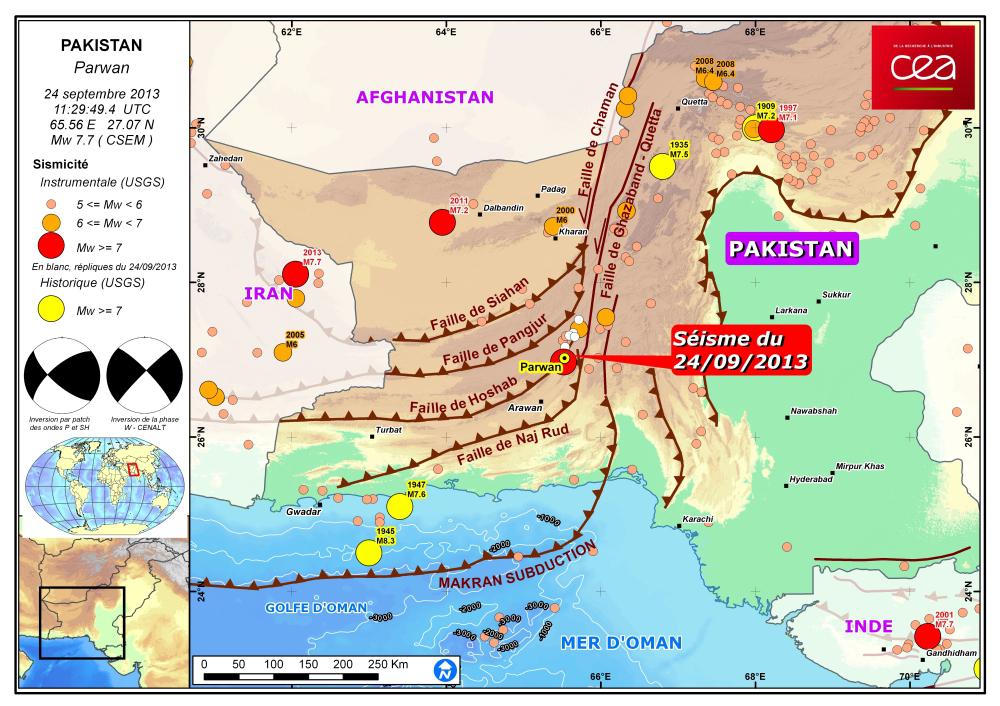
 Figure 1: Map showing location of the earthquake of 24 September 2013, major faults of the region and seismicity (1973-2013). Focal mechanisms calculated at the CEA by 2 methods (see below for description of the results).
Seismic source: inversion of the phase W
The data received from the seismic stations were used to determine the earthquake mechanism by inversion of the W-phase at teleseismic distances (Z. Duputel et al., 2012). The mechanism obtained shows a strike-slip type source. Considering the SSW-NNE orientation of the faults and aftershocks (Fig. 1), the focal mechanism is consistent with sinistral strike-slip faulting.
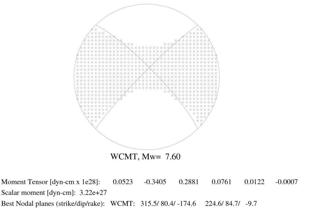
Figure 2: Focal mechanism obtained by inversion of the W-phase at teleseismic distances (Z. Duputel et al., 2012).
In Fig. 3, we show the fitting of 3 of the 110 seismograms used for the W-phase inversion.
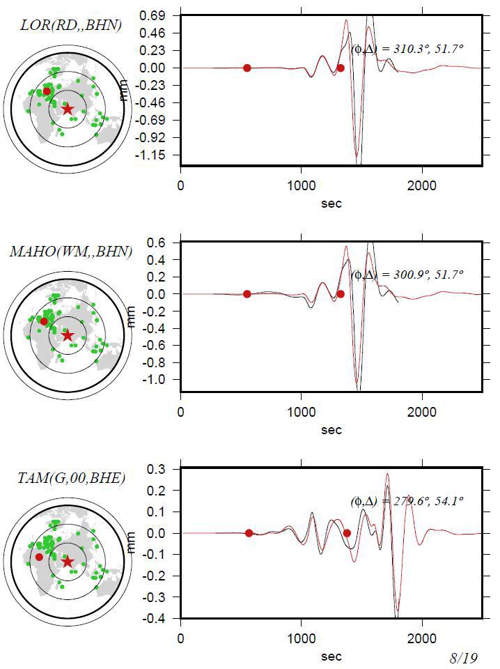
Fig 3: 3 of the 110 seismograms used for inversion of the W phase. Observations in black and simulation in red.
Kinematic imaging of the rupture
The source of the earthquake was analysed using the signals recorded at great distances on worldwide networks of seismic stations (IRIS and CEA). This approach, also known as kinematic inversion, allows us to obtain a precise description of the seismic source, i.e. how the rupture is propagated on the fault (method of patches; Vallée and Bouchon: Imaging co-seismic rupture in far-field by slip patches, JGI, 2004). In addition to confirming the magnitude, this analysis provides the characteristic dimensions of length, duration and slip necessary to understand the rupture. The length of rupture for the earthquake of 24 September is about 200 km, with directivity primarily oriented towards the north-east.
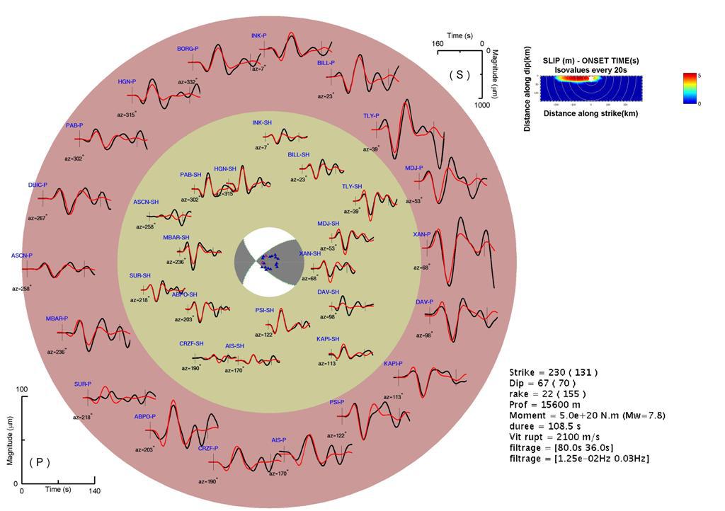
Figure 4: Inversion of the earthquake of 24 September 2013. The results yield a source magnitude of 7.8 with a rupture directivity towards the north-east (consistent with the distribution of aftershocks).
Tide-gauge observations
Variations of the sea level were observed following the seismic event (Figure 5, source PTWC). Surface waves related to the earthquake were recorded by the DART buoy (India), which is located approximately 300 km off the coast. After approximately 50 min, the same buoy then recorded a series of “surges” with an amplitude of 1 cm. The tide-gauge in the port of Muscat (Oman) recorded a wave train 30 min after the earthquake, with waves reaching a peak-to-trough height of 40 cm. Lastly, two Iranian tide-gauge stations (Chabahar and Jask) recorded movements at the onset time of the earthquake, which were followed at least 30 minutes later by a series of tide-gauge signals.
This whole set of tide-gauge recordings indicates a disturbance whose origin remains to be determined.
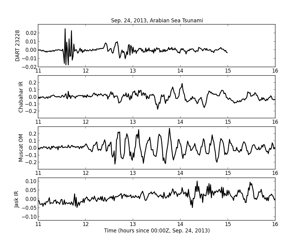
Figure 5: Variations of sea level in metres measured by the DART 23228 buoy (India) and by 3 tide-gauges (Oman and Iran), following the Pakistan earthquake (source D. Wang, PTWC).
Z. Duputel, L. Rivera, H. Kanamori, G. Hayes, 2012. W-phase fast source inversion for moderate to large earthquakes (1990 - 2010), Geophysical Journal International, v. 189, iss. 2, p. 1125-1147.
Vallée M. and Bouchon M.: Imaging co-seismic rupture in far-field by slip patches, JGI, 2004
(link towards the Scardec WEB site: https://geoazur.oca.eu/spip.php?article1236)
|
|
|
)
)
)
)
)