 |
 |
 |
|
 |
|
|
|
Scientifiques files |
|
|
| |

|
Earthquake of 16 April 2015 to the south-east of Crete (Mw = 6.0) |
As expected for this level of magnitude, no tsunami was observed following this event. It should be noted that no operational tide gauge was located at less than 300 km from the epicentre.
The French warning system installed at CEA (CENALT) detected and characterized the earthquake. It informed the authorities of the absence of risk for the French coasts. Indeed, the passage of tsunamis from east to west in the Mediterranean is only possible in cases of much higher magnitude (> 8).
 Context
The earthquake took place to the south-east of Crete. This highly seismic area is slowly accommodating (at ca. 5 mm/year) the convergence of the African and Eurasian plates, across a subduction zone extending from the south-west of Greece to the south of Turkey (Figure 1). The zone has been affected in the past by major earthquakes, the strongest of which generated major tsunamis.
For example, in 1303, an earthquake of magnitude close to 8 generated a tsunami with an amplitude of several metres which was observed in the eastern Mediterranean and north of Africa. The area was also affected in 365, in the Western part of the subduction zone, by an earthquake of the same order of magnitude, causing a tsunami observed in the Adriatic.
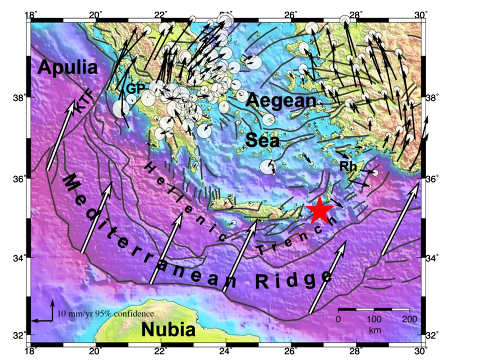
 Figure 1 : Context of epicentral area showing convergence of the African plate towards Eurasia (white arrows), as well as strain rates around the Aegean Sea (black arrows) with Eurasia taken as fixed (After Vernant et al., 2014)
Kinematic source inversion
Approximately 30 minutes after the earthquake, application of the W phase source inversion algorithm confirmed the magnitude MW = 6.0, with a thrusting mechanism comprising a notable strike-slip component (Figure 2). This mechanism is consistent with NE-SW thrust faulting also affected by strike-slip movement.
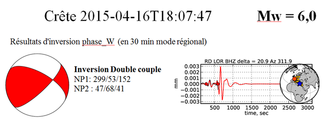
Figure 2 : Source inversion for the earthquake of 16 April 2015, obtained at CENALT 30 minutes after the earthquake using W phase source inversion algorithm (Kanamori and Rivera, 2008). Signal recorded at Lormes seismic station.
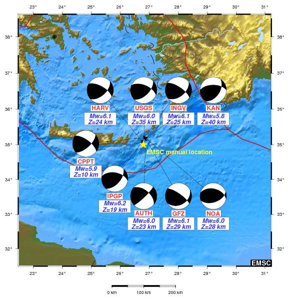
Figure 3: Focal mechanisms obtained by various institutes (source CSEM).
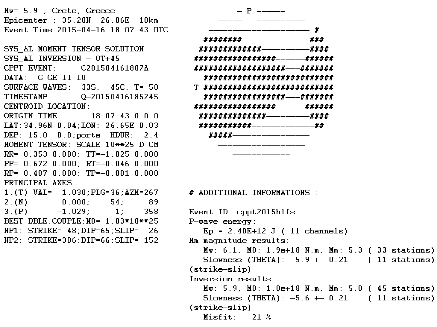
Figure 3-bis : At bottom, inversion of surface waves obtained 45 minutes after the earthquake, carried out at the CEA laboratory of Pamatai.
Sea level measurements and tsunami simulation
Few tide-gauge data are available in the zone of the earthquake (Figure 4). The stations near Crete (green circles) did not in fact record any data on the day of this earthquake. Thus, only the recording from the tide gauge at Alexandria could be analysed, but it did not detect any tsunami signal.
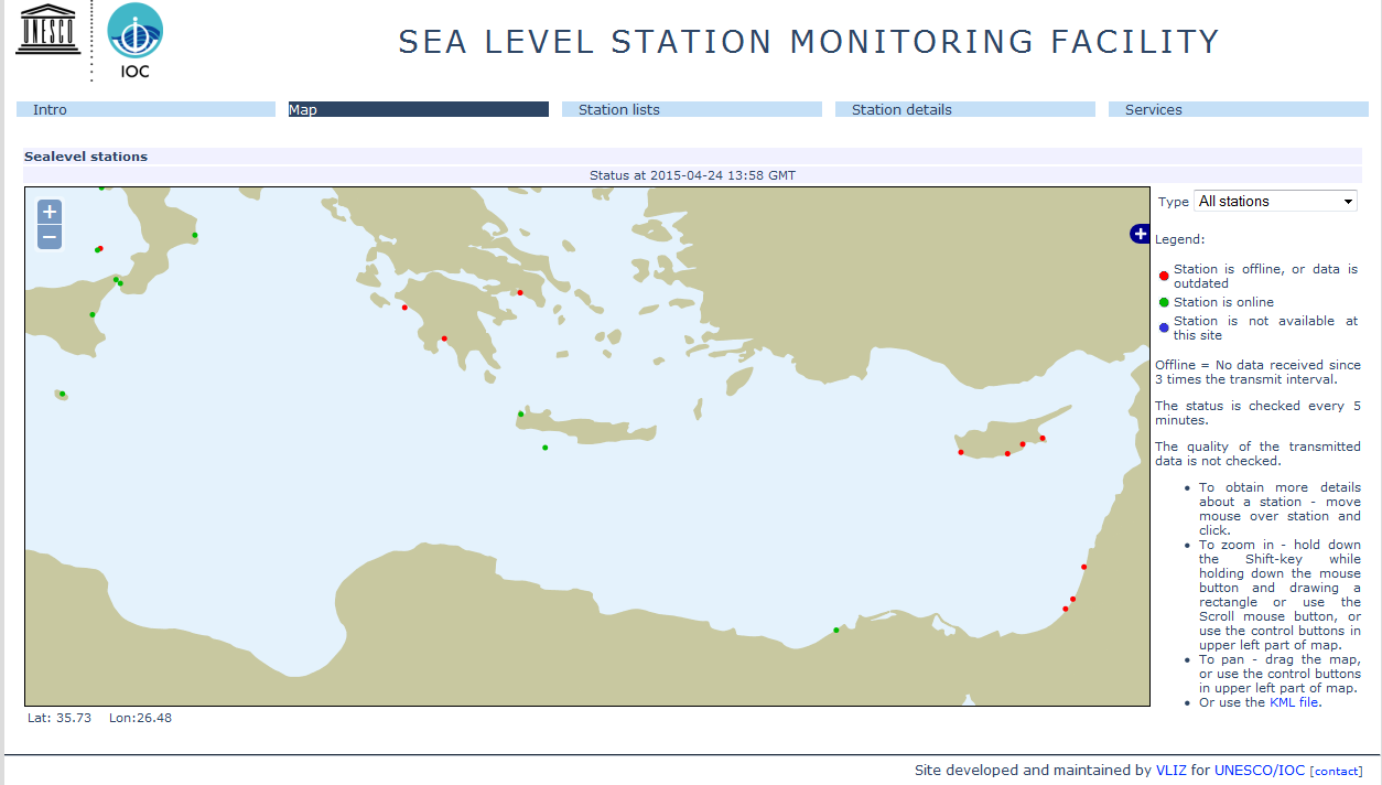
Figure 4: Screen capture from web-site UNESCO/IOC-VLIZ(http://www.ioc-sealevelmonitoring.org) showing position of sea level measuring stations available in real time in the epicentral zone.
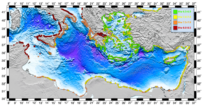
Figure 5: Minimal magnitude necessary to obtain a wave height of 50 cm at the coast for shallow earthquakes localized along the Hellenic subduction zone (according to Necmioglu and Özel, 2015).
According to a recent study by Necmioglu and Özel (2015), an earthquake with a magnitude of at least 8.0 in the Eastern Mediterranean would be necessary to generate a tsunami able to flood (Red Alert) certain coasts in the eastern part of the Western Mediterranean (Figure 5). However, it is possible that tsunamis triggered by these very strong earthquakes (M > 8.0) would lead to strong currents and drops in sea level in harbours and estuaries located along on the eastern coast of Corsica and in the Gulf of Lions (orange alert level).
Kanamori H. and Rivera L. (2008), Source inversion of W phase: speeding up seismic tsunami warning, Geophys. J. Int., 175, 222–238, .doi:10.1111/j.1365-246X.2008.03887.x
CSEM : page de l’événement : http://www.emsc-csem.org/Earthquake/earthquake.php?id=436951
Necmioglu O. and Özel N. M. (2015), Earthquake Scenario-Based Tsunami Wave Heights in the Eastern Mediterranean and Connected Seas, Pure Appl. Geophys., doi:10.1007/s00024-015-1069-y.
Vernant P., Reilinger R., and McClusky S. (2014) Geodetic evidence for low coupling on the Hellenic subduction plate interface, Earth Planet. Sci. Lett., 385, 122-129, doi:10.1016/j.epsl.2013.10.018.
|
|
|
)
)
)
)
)
)