 |
 |
 |
|
 |
|
|
|
Scientifiques files |
|
|
| |

|
Nepal earthquakes of 25 April and 12 May 2015 |
 Nepal earthquakes of 25 April and 12 May 2015
An earthquake of magnitude 7.8 took place on 25 April 2015 at 6h11 UT in Nepal (11h56 local time). Its epicentre was located 80 km to the North-West of the capital Kathmandu. This earthquake occurred in the collision zone between two major tectonic plates, the Indian and the Eurasian plates. The focal mechanism displays a purely thrust faulting motion consistent with the reverse fault displacement of the main Himalayan thrust. In the 48 hours following the main event, 49 aftershocks were recorded, including 40 with a magnitude exceeding 4.5. Twenty of these events had a magnitude of more than 5, while two were of magnitude 6 or more.
Following this powerful earthquake, a second major event took place on 12 May 2015 at 7h05 UT, with a magnitude of 7.3 and located at the eastern end of the first rupture zone (Fig. 1).
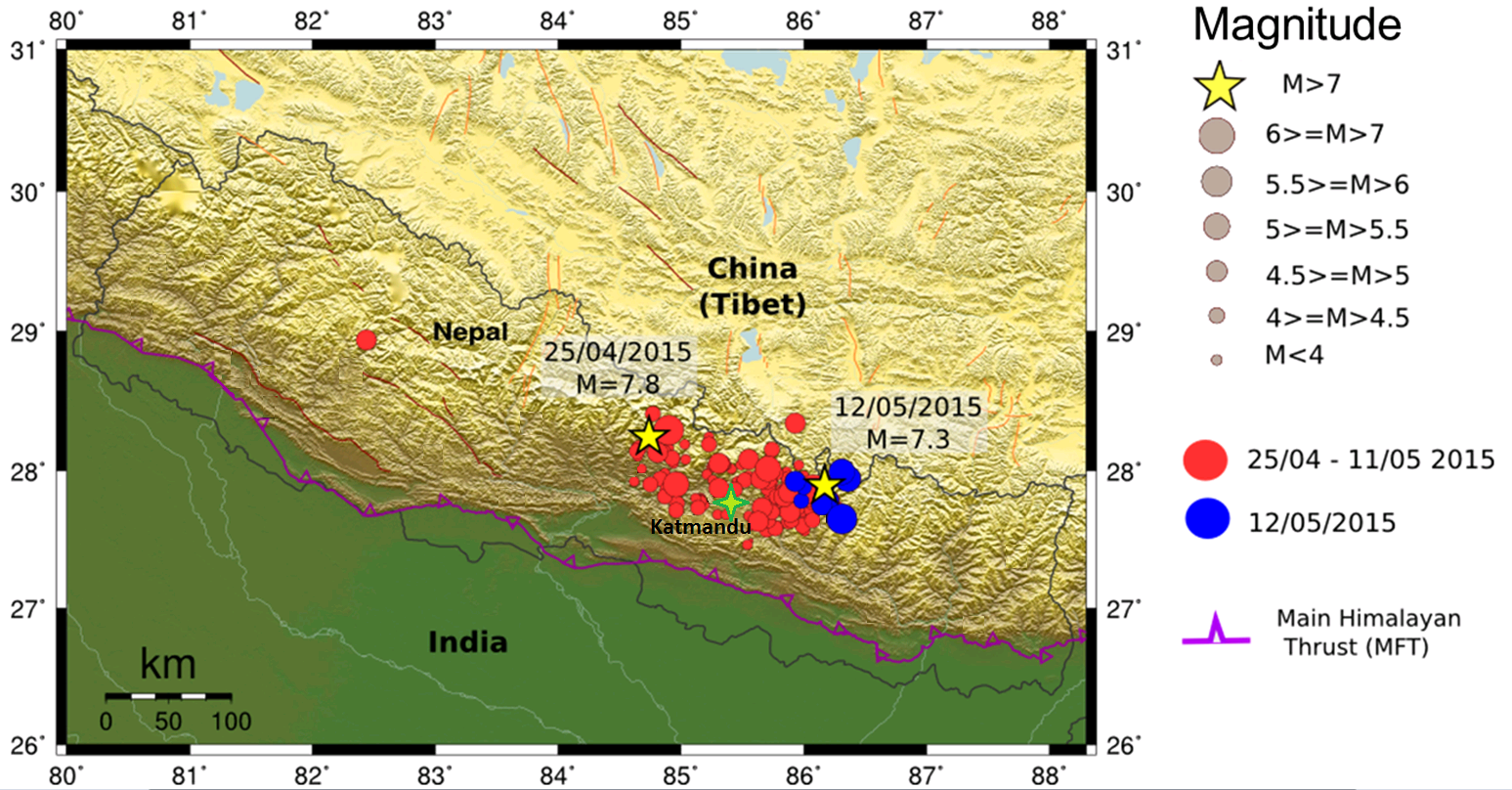
 Figure 1: Earthquakes of 25 April and 12 May 2015 (yellow arrows), with location of aftershocks (data source: CSEM).
Localization and seismotectonic context of seismic crisis.
The region affected by this seismic crisis has already suffered several major historical earthquakes of magnitude greater than 7. It was devastated by the magnitude-7.7 (macroseismic) earthquake of 1833 and the great Nepal-Bihar earthquake of 1934, whose magnitude is estimated at 8.2-8. (Figure 2).
These earthquakes occurred in the collision zone between two major tectonic plates: the Indian plate is converging relative to Eurasia at a rate of approximately 4 cm/year. Half of this convergence (2 cm/year) is accommodated by shortening across the Himalayan chain on a major thrust fault which forms the main Himalayan thrust front.
The seismicity of Nepal, and more particularly the Himalayan chains, results from this collision between the Indian and Eurasian plates. The Himalayan main thrust fault (MFT, Main Frontal Thrust) produces very strong destructive earthquakes which exposes Nepal, but also the North of India, to a very high level of seismic risk. This fault is locked in its upper part over the periods which separate strong seismic events. Over this interseismic period, the fault produces numerous small magnitude earthquakes, including several that are felt by the local population every month. These small seismic events dissipate a negligible seismic energy compared with the strong earthquakes.
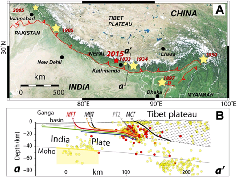
Figure 2 (modified after Bollinger et al., 2014): Top: localization of earthquake of 25 April 2015 (red star) and historical earthquakes (yellow stars) along the Himalayan main thrust (red line with barbs). Bottom: cross-section of active seismic area along transect aa'. Seismicity during interseismic period (in red: at level of Kathmandu, in yellow: eastern Nepal).
Seismic sequence/aftershocks
Forty eight hours after the main event, the worldwide networks recorded forty-nine aftershocks; forty of these earthquakes had a magnitude greater than 4.5, with twenty greater than 5 and two greater than 6. These aftershocks are located along the whole of the rupture zone and mainly on the eastern part of the rupture (Figure 1 and Figure 5). Between 25 April and 11 May 2015, approximately 130 aftershocks of magnitude exceeding 4 were recorded by the worldwide seismic networks. The seismic crisis of 12 May represents a continuation of the first rupture, displaying a bilateral rupture pattern and leading to about ten aftershocks of magnitude greater than 4 occurring in the following twelve hours.
Characteristics of the source
W phase source inversion:
Data from seismic stations were used to determine the earthquake mechanism by inversion of the W phase at teleseismic distances (Kanamori and Rivera, 2008). The mechanism obtained (Fig. 3) shows a purely thrusting-type source consistent with the reverse fault movement of the Himalayan main thrust. The nodal planes of the double couple are (strike/dip/rake): 295/6/108 and 96/85/88.
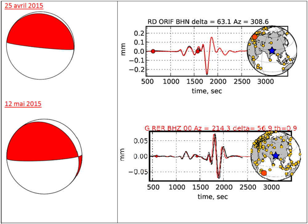
Figure 3: On left, focal mechanism obtained by inversion of the W phase at teleseismic distances, for the earthquakes of 25 April and 12 May 2015. On right, example of seismograms (ORIF station located in France, red circle on globe, and RER station on Reunion Island) used for the W phase inversion. Note the good agreement between the observation in black and the simulation in red.
Kinematic inversion:
The source of the earthquakes was also analysed using the signals recorded at long distance by seismic stations belonging to the worldwide networks (IRIS and CEA). This approach allows us to obtain a precise description of how the rupture is propagated on the fault using a minimum of parameters (method of patches; Vallée and Bouchon, 2004).
For the earthquake of 25 April 2015, the length of rupture obtained is about 100 km with a directivity primarily towards the south-east (Fig. 3). The solution given by the inversion yields a maximum compact slip of around 3 m. For the earthquake of 12 May, the rupture directivity is clearly bilateral, with a duration of 15 s and a maximum slip of about 2 m (Figure 4 – at bottom).
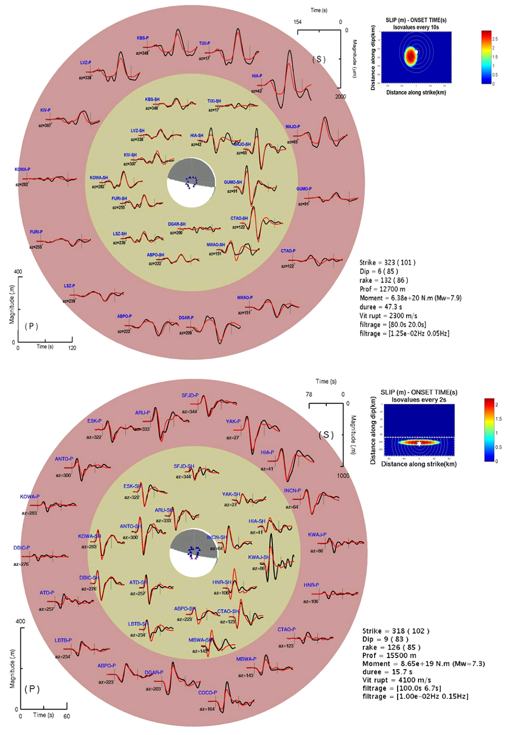
Figure 4: Kinematic inversion of the earthquakes of 25 April 2015 (at top) and 12 May 2015 (at bottom). The results for the 25 May event lead to a source magnitude of MW 7.8, with a rupture directivity towards the south-east (consistent with the distribution of aftershocks). For the earthquake of 12 May 2015, the directivity pattern is bilateral, with a rupture duration of about 15 s.
Synthesis:
The rupture of the earthquake of 25 April 2015 appears to be similar to that of 1833, with the zone of slip corresponding to the zone of maximum damage of this historical earthquake (Figure 2).
During the first 48 hours after the main seismic event, the aftershocks remained localized within the probable rupture zone and did not affect other segments of the Himalayan main thrust to the south and west of the epicentre (Fig. 5). The rupture zone for the event of 12 May is very close to the main aftershock of magnitude 6.7 that occurred on 25 April.
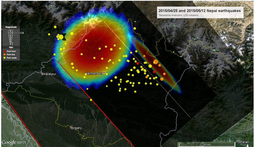
Figure 5: Distribution of coseismic slip obtained by kinematic inversion for the earthquakes of 25 April and 12 May 2015, with location of aftershocks.
Bollinger L., S. N. Sapkota, P. Tapponnier, Y. Klinger, M. Rizza, J. Van der Woerd, D. R. Tiwari, R. Pandey, A. Bitri, and S. Bes de Berc (2014), Estimating the return times of great Himalayan earthquakes in eastern Nepal: Evidence from the Patu and Bardibas strands of the Main Frontal Thrust, J. Geophys. Res. Solid Earth, 119, 7123-7163, doi:10.1002/2014JB010970.
Kanamori H. and Rivera L. (2008), Source inversion of W phase: speeding up seismic tsunami warning, Geophys. J. Int., 175, 222–238, doi:10.1111/j.1365-246X.2008.03887.x.
Vallée M. and Bouchon M. (2004), Imaging coseismic rupture in far-field by slip patches, Geophys. J. Int., 156, 615-630, doi:10.1111/j.1365-246X.2004.02158.x.
Vallée M., Charléty J., Ferreira A. M., Delouis B., Vergoz J. (2011), SCARDEC: a new technique for the rapid determination of seismic moment magnitude, focal mechanism and source time functions for large earthquakes using body-wave deconvolution, Geophys. J. Int., 184, 338-358, doi:10.1111/j.1365-246X.2010.04836.x.
|
|
|
)
)
)
)
)