 |
 |
 |
|
 |
|
|
|
Scientifiques files |
|
|
| |

|
Information on the Perpignan earthquake of 29/10/2015 at 00h37 UT |

On 29 October 2015 at 00h37 UT (01h37 French local time), the Detection and Geophysics Laboratory (LDG) located an earthquake of magnitude 4.5 with an epicentre located approximately 43 km south-south-east of Perpignan and 41 km to the south-east of Céret (Figure 1).
|
Onset time |
29/10/2015 at 00:37:48 UT |
|
Location |
41 km south-east of Céret |
|
Latitude |
42.26° N |
|
Longitude |
3.15° E |
|
Magnitude |
4.5 (ml) |
|
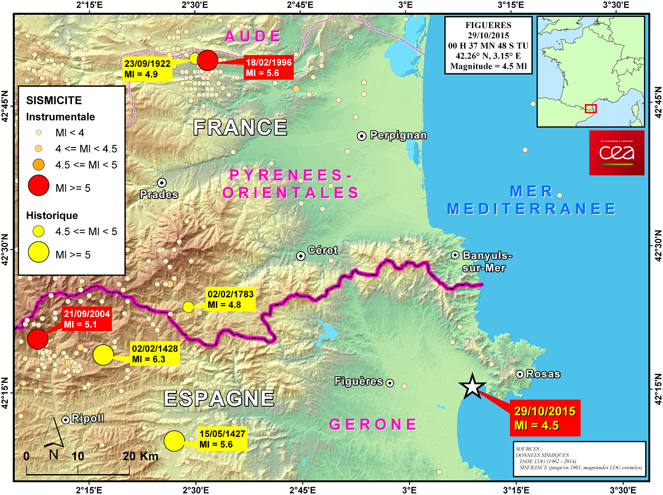
 Figure 1: Map showing location of the seismic event of 29 October 2015
Geodynamic context (Figures 2a and 2b)
The seismic event of 29 October 2015 occurred in the Bay of Roses, at the northern end of the Catalan continental shelf, which is bounded to the north by the Cap de Creus canyon (96 km long) and to the south by the of Fonera canyon (105 km long) (Lastras et al., 2011). This sector of the Spanish passive margin is at the extreme northern end of the Valencia Basin, which represents the western extension of the Provençal basin. The genesis of this basin is linked to the relative movements of convergence between the continental plates of Africa and Europe, which led to the successive opening of the West-Mediterranean basins from east to west over the last 30 million years. The Provençal basin opened during the late Oligocene – early Miocene, at the same time as the rotation of the Corso-Sardinian blocks (Gueguen et al., 1998). While the substratum displays a low degree of extension in the area of the Valencia Trough, the deformation indicates that the opening took place along transverse NW-SE faults subdividing the Valencia Basin into several compartments, with crustal thinning increasing towards the NE (Maillard, 1993; Maillard and Mauffret, 1999). Recent seismic data as well as the seismotectonics show that the zone is currently undergoing reactivation.
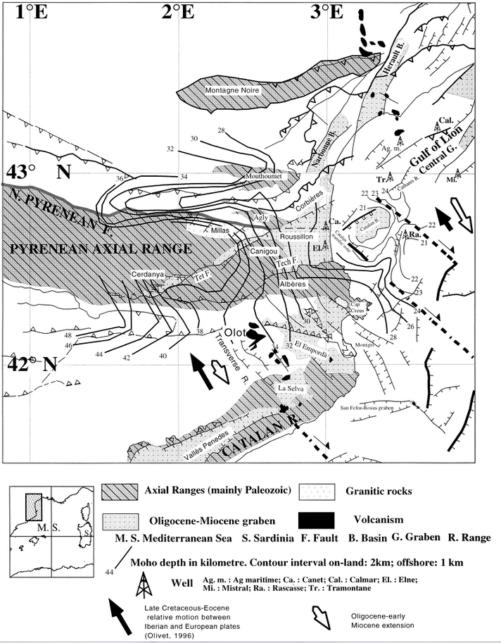
Figure 2a: tectonic setting of the Pyrenees and Gulf of Lions, according to Mauffret et al. (2001). The Moho deepens under the massifs of Canigou and Albères, as well as under the headlands of Cap de Creus and Rascasse, and becomes thinner under the Catalan basin.
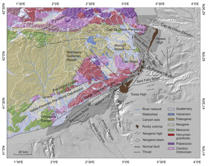
Figure 2b: Geological map of the northern Catalan margin, according to Duran et al. (2014). BF: Barcelona Fault. CBF: Costa Brava Fault.
Historical seismicity
No remarkable historical earthquake is recognized in this part of Catalonia. However, about 60 km farther west, it is noteworthy that a major seismic crisis took place during medieval times (1427 to 1450) in the area around Olot (of intensity IX on the MSK scale) which lastingly affected a large part of this region.
Seismic signals
All the seismic stations of the DASE network in France detected the signals from this earthquake, which made it possible to process the event (Figures 3 and 4).
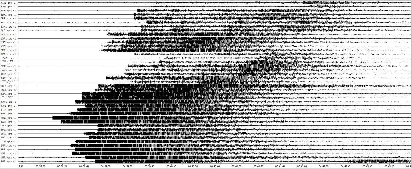
Figure 3: Seismic signals of the earthquake south-east of Perpignan on 29/10/2015 recorded by 41 seismic stations of the DASE. A T-wave signal is visible on the PGF at 00:42:40 UT.
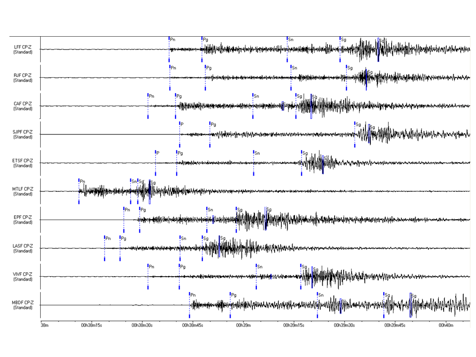
Figure 4: Treatment of seismic signals from the earthquake of 29/10/2015 south-east of Perpignan recorded on seismic stations of the DASE.
Determination of the focal mechanism
The determination of the focal mechanism (Figures 5 and 6) shows a NW-SE trending fault compatible with the geodynamic context described above.
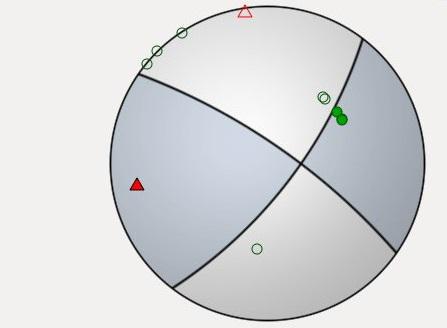
Figure 5: Focal mechanism determined from the polarities of signals recorded by regional stations
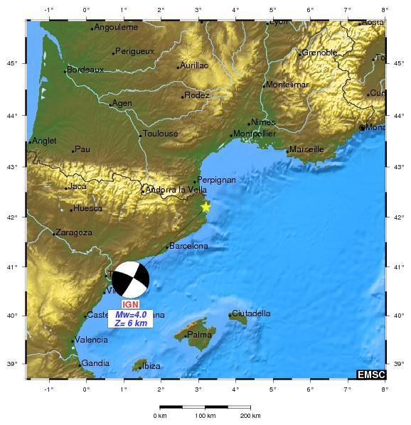
Figure 6: Focal mechanism published by the IGN (Instituto Geográfico Nacional- Spain) at the CSEM (Euro-Mediterranean Seismological Centre).
- Duran R., Canals M., Sanz J. L., Lastras G., Amblas D., Micallef A. (2014), Morphology and sediment dynamics of the northern Catalan continental shelf, northwestern Mediterranean Sea, Geomorphology 204, 1-20, doi:10.1016/j.geomorph.2012.10.004.
- Gueguen E., Doglioni C., Fernandez M. (1998), On the post-25 Ma geodynamic evolution of the western Mediterranean, Tectonophysics 298, 259-269, doi:10.1016/S0040-1951(98)00189-9.
- Lastras G., Canals M. et al. (2011). Understanding sediment dynamics of two large submarine valleys from seafloor data: Blanes and La Fonera canyons, northwestern Mediterranean Sea, Mar. Geol. 280, 20-39, doi:10.1016/j.margeo.2010.11.005.
- Maillard A. (1993), Structure et riftogenèse du golfe de Valence(Méditerranée Occidentale), Thèse de doctorat de luniversité Paris 6.
- Maillard A., Mauffret A. (1999), Crustal structure and riftogenesis of the Valencia Trough (north-western Mediterranean Sea), Basin Res. 11, 357-379, doi:10.1046/j.1365-2117.1999.00105.x.
- Mauffret A., Durand de Grossouvre B. , Dos Reis A. T., Gorini C., Nercessian A. (2001), Structural geometry in the eastern Pyrenees and western Gulf of Lion (Western Mediterranean), J. Struct. Geol. 23, 1701-1726, doi:10.1016/S0191-8141(01)00025-6.
|
|
|
)
)
)
)
)
)
)