| |


|
Information on the Al Hoceima earthquake of 25/01/2016 at 04h22 UT |
On 25 January 2016 at 04h22 UT (05h22 Spanish and French local time), the Detection and Geophysics Laboratory (LDG) located an earthquake of magnitude 6.4 whose epicentre was located approximately 50 km to the north of Al Hoceima (Morocco) (Figure 1). This earthquake was followed by several aftershocks felt in Spain and Morocco, with one of these events reaching a magnitude of 5.2.
Eight minutes after the earthquake, a tsunami alert was issued by the CENALT (French national tsunami warning centre) at international level, as well as via a news bulletin for the national authorities. The alert level corresponded to a warning within a radius of 400 km from the epicentre (for Spain, Morocco, Algeria and Gibraltar), while a message of information was transmitted for areas located at more than 400 km from the epicentre.
- Onset time: 25/01/2016 at 04:22:01 UT
- Location: 62 km to the north of Al Hoceima
- Latitude: 35.53° N
- Longitude: 3.81° E
- Magnitude: 6.4
- Depth : < 20 km
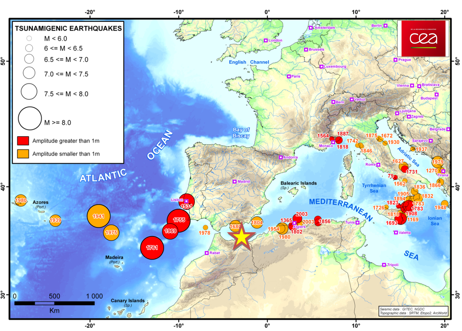
 Figure 1: Historical seismicity of tsunamigenic or potentially tsunamigenic events. The Alboran earthquake of 25/01/2016 at 04h22 UT is represented by a yellow star.
 Tectonic context and regional seismicity
The earthquake of 25 January 2016 occurred in the Alboran Sea of the Western Mediterranean close to the Moroccan coast (Fig. 1). This region is characterized by complex seismic activity resulting from the deformation induced by the convergence of the African and Eurasian tectonic plates. The region has been subject to historical and instrumental earthquakes of magnitude 6 to 7, some of which generated tsunamis (e.g. 1680 and 1804).
- The deformation is accommodated in the epicentral zone and, farther south in the Rif, by a complex set of conjugate faults, which affect a large part of the trans-Alboran shear zone (Fig. 2).
- Over recent years, the area around Al Hoceima has proved to be the most seismically active zone in this part of the Western Mediterranean (Fig. 3). Indeed, this zone has been hit by two earthquakes, of magnitude 6.0 and 6.4, in 1994 and 2004. In particular, the earthquake of 24 February 2004, located less than 50 km to the south of the event of 26 January 2016, occurred on a very similar sinistral strike-slip fault plane. With an epicentre close to the coast, very near the town of Al Hoceima, the earthquake of 24 February 2004 led to 630 fatalities.
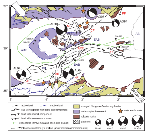
Figure 2: Structural map of the Alboran Sea showing recent structures and main sedimentary depocentres, as well as the principal earthquakes and focal mechanisms associated with the seismic swarms of Adra and Al Hoceima (Stich et al. 2001, 2003; Biggs et al. 2006). According to Martinèz-Garcia et al. (2011).
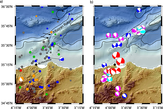
Figure 3: (a) Distribution of seismicity and focal mechanisms on the Moroccan margin of the Alboran Sea [colour code for focal depth: blue 1-5 km, green 5-20 km, orange 20-50 km, red 50-110 km, grey = gap > 180°]. (b) Same zone with focal mechanisms derived from inversion of moment tensors [red: gCMT (http://www.globalcmt.org/CMTsearch.html); other colours: focal mechanisms from Stich et al. (2003, 2005, 2006 and 2010)]. The size of the beach-ball diagram is proportional to the earthquake magnitude; the arrows indicate fault traces. (according to Grevemeyer and Al, 2015).
Calculation of focal mechanisms
Figure 4 shows the focal mechanisms calculated by source inversion of the W phase (Kanamori and Rivera, 2008).
A first solution (denoted 1 on Figure 4) was obtained within 40 minutes following the seismic event (after counting 62 phases), then a second solution (denoted 2) approximately 6 hours later (after counting 64 phases). The two solutions are highly consistent and yield a moment magnitude MW of 6.4. The mechanism obtained shows a source with a mainly strike-slip component. The nodal planes of the double couple give a north-eastern/south-western azimuth and a dip towards the north.
For comparison, Figure 4 and Table 1 report the GCMT focal mechanism (denoted 3 on figure 4) obtained approximately 9h30 after the earthquake.
Figure 5 includes the mechanisms transmitted to the CSEM by various data providers.
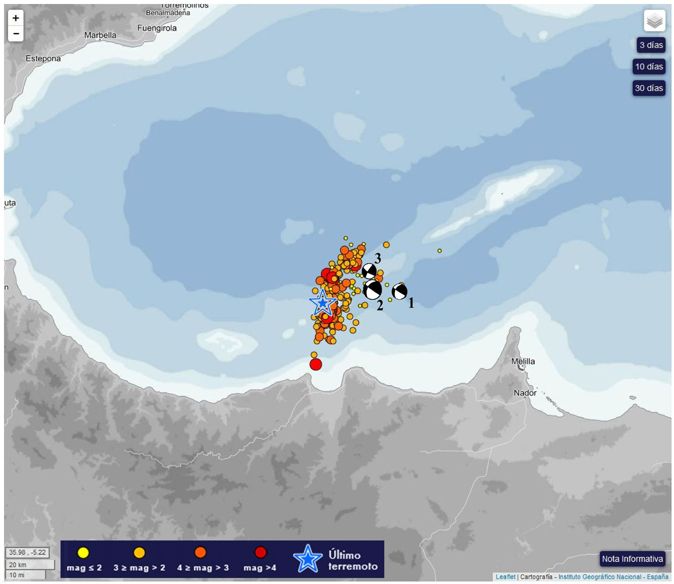
Figure 4: GCMT mechanisms (denoted 3), compared with mechanisms calculated by the CENALT based on W phase inversion obtained 40 min after the earthquake (1, MW = 6.4, with 62 phases,) and then after 6 hrs (2, MW = 6.4, with 64 phases) (see also Table 1). The coloured circles represent aftershocks located on the Spanish National Geographic Institute site.
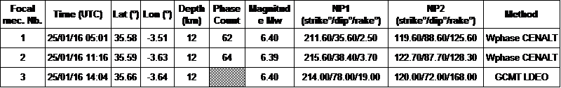
Table 1: Source parameters and solution time for the three focal mechanisms plotted on Fig. 4.
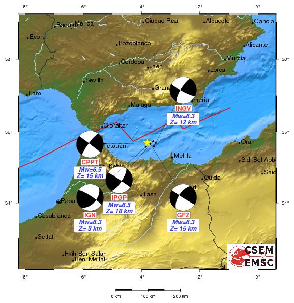
Figure 5: Focal mechanisms for the earthquake of 25/01/2016 from information sent to the CSEM by 5 data providers.
Tide-gauge data and measurement of the tsunami
A tsunami of very low amplitude was observed on the tide-gauge data available in real time at the CENALT.
Recordings of the Spanish radar sensors (sampling step: 1 min) were downloaded from the Web site of the IOC (www.ioc-sealevelmonitoring.org) and then treated for several Spanish stations (Figure 6). The filtered signal (red curve, middle spectrogram), for the stations of Motril and Malaga on the Spanish coast, yields maximum peak-to-trough amplitudes of 3 to 4 cm.
The spectrograms show that this phenomenon is associated with a period of approximately 10 min (Motril) or 20-30 min (Malaga). The station of Melilla (MELI), located on the edge of the Moroccan margin, does not show a tsunami signal.
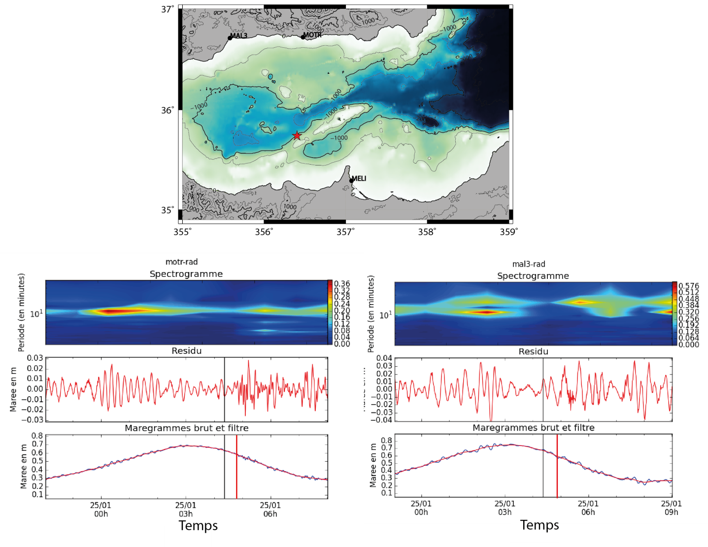
Figure 6: Tide-gauge recordings from Motril (MOTR) and Malaga (MAL3) over the period of the earthquake of 25 January 2016, analysed at the CENALT (see map at top for location of sites). The black vertical line indicates the onset time of the earthquake, and the red vertical line the theoretical time of arrival of the 1st tsunami wave.
Biggs, J., Bergman, E., Emmerson, B., Funning, G. J., Jackson, J., Parsons, B., & Wright, T. J. (2006). Fault identification for buried strike-slip earthquakes using InSAR: The 1994 and 2004 Al Hoceima, Morocco earthquakes. Geophysical Journal International, 166(3), 1347-1362, doi :10.1111/j.1365-246X.2006.03071.x
CSEM : page de l’événement : http://www.emsc-csem.org/Earthquake/earthquake.php?id=484213
Grevemeyer, I., Villasenor, A., & Leuchters, W. (2011). Seismotectonics of the Alboran domain, Western Mediterranean–active shallow tectonics and deep-seated shadows of the past. Geophysical Research Abstracts 13, EGU2011-4930
Kanamori, H., & Rivera, L. (2008). Source inversion of W phase: speeding up seismic tsunami warning. Geophysical Journal International 175(1), 222-238, doi:10.1111/j.1365-246X.2008.03887.x
Martinez-Garcia, P., I. Soto, J. et Comas M. (2011), Recent structures in the Alborian Ridge and Yusuf fault zones based on swath bathymetry and sub-bottom profiling : evidence of active tectonics. Geo-Mar Lett, 31, 19-36, doi :10.1007/s00367-010-0212-0
Stich, D., Ammon, C. J., & Morales, J. (2003). Moment tensor solutions for small and moderate earthquakes in the Ibero‐Maghreb region. Journal of Geophysical Research: Solid Earth, 108(B3), 2148, doi:10.1029/2002JB002057
Stich, D., Mancilla, F. D. L., Baumont, D., & Morales, J. (2005). Source analysis of the Mw 6.3 2004 Al Hoceima earthquake (Morocco) using regional apparent source time functions. Journal of Geophysical Research: Solid Earth , 110(B6), B06306, doi: 10.1029/2004JB003366
Stich, D., Serpelloni, E., de Lis Mancilla, F., & Morales, J. (2006). Kinematics of the Iberia–Maghreb plate contact from seismic moment tensors and GPS observations. Tectonophysics, 426(3), 295-317, doi:10.1016/j.tecto.2006.08.004
Stich, D., Martín, R., & Morales, J. (2010). Moment tensor inversion for Iberia–Maghreb earthquakes 2005–2008. Tectonophysics, 483(3), 390-398, doi:10.1016/j.tecto.2009.11.006
|
)
)
)
)
)
)
)