 |
 |
 |
|
 |
|
 |
|
|
|
Seismic hazard assessment |
|
|
|
|
|
 Seismic hazard and seismic risk Seismic hazard and seismic risk |
|
|
|
Seismic hazard |
|
|
|
Study of the probability of an earthquake reaching or exceeding a given intensity at a given location within a given reference period. |
|
|
|
Seismic risk |
|
|
|
Calculation of the probability and damage level within a reference period and in a given region.
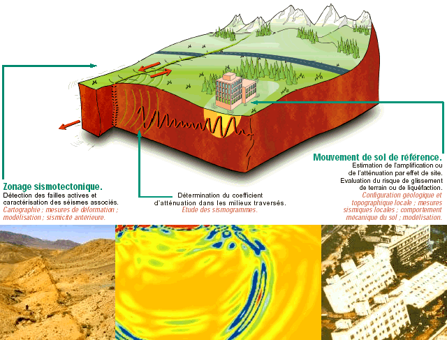
Seismic hazard assessment involves two steps:
|
 |
The first is to characterize seismic sources in terms of location, magnitude, and recurrence. After integration of geological and seismic data, eventually followed by field data acquisition, seismotectonic zoning is performed. |
|
|
The second step involves defining benchmark ground movements that depend on the potential seismic sources derived from seismotectonic zoning, on the waves attenuation, and on the sites' geological and topographic configurations. |
 |
Left: active fault (Mongolia)
Center: seismic wave propagation modeling
Right: Niigata, Japan, 1964: the ground in the most sensitive areas liquefied under the effect of the earthquake, causing apartment buildings to topple over. |
To accomplish the seismic hazard studies, the environmental assessment and monitoring Department (Département analyse, surveillance, environnement, DASE) of the military applications Division (Direction des Application Militaire, DAM) conducts or takes part in research and development initiatives in various fields. |
|
|
|
Near-field source and propagation studies |
|
|
|
Thanks to the acquisition of strong ground motion experimental data and numerical modeling, we aim to reach a better understanding of near-field motion variability, i.e. in the most sensitive areas.
Construction of underground installations also requires a greater understanding of the physical and geological parameters that condition variations in the amplitude and form of seismic signals with depth. |
|
|
|
Site effects and vulnerability |
|
|
|
Site effects, which can modify the seismic signal significantly, represent a kind of natural vulnerability that is beginning to be taken into consideration in regulations. A number of fundamental issues are still to be clarified, concerning in particular the real effect of topographies, the influence of lateral variations in speed or wave trapping in sedimentary basins. |
|
|
|
Probabilistic studies |
|
|
|
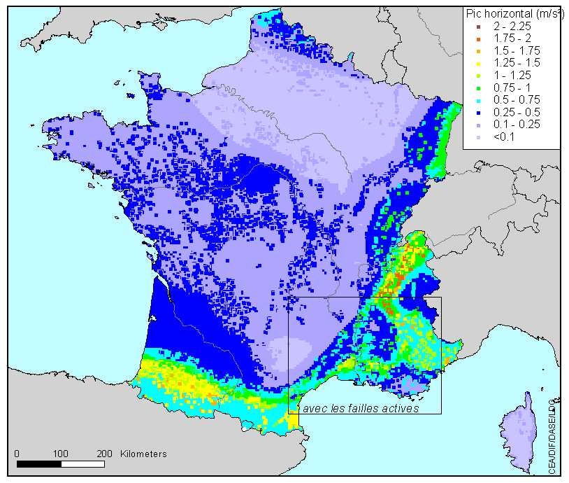
The majority of regulations currently in force around the globe, either for "standard" risks, or for industrial or nuclear facilities, explicitly require a probabilistic approach in seismic hazard assessment (International Atomic Energy Agency, great dams, standard risk in France, European regulation Eurocode 8, etc.). For many years now, the DASE has been working on this methodology and today has an operational tool at its disposal for assessing seismic hazard on a given site.
|
Expected peak ground acceleration for a 1975-years return period in France. |
|
|
|
|
Seismotectonics and paleoseismicity |
|
|
|
France |
|
|
|
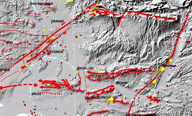
In France, strong earthquakes are scarce events (see Seismicity information) that only very rarely occur in the same place (on the scale of human memory). We therefore cannot hope to have an exhaustive picture of a region's potential seismicity solely based on historical and instrumental seismic data. Therefore, the search for neotectonic indices and paleo-earthquakes, and the use of deformation measurements (GPS - Global Positioning System) are essential tools for analyzing past seismicity.
|
|
|
|
Mongolia |
|
|
|
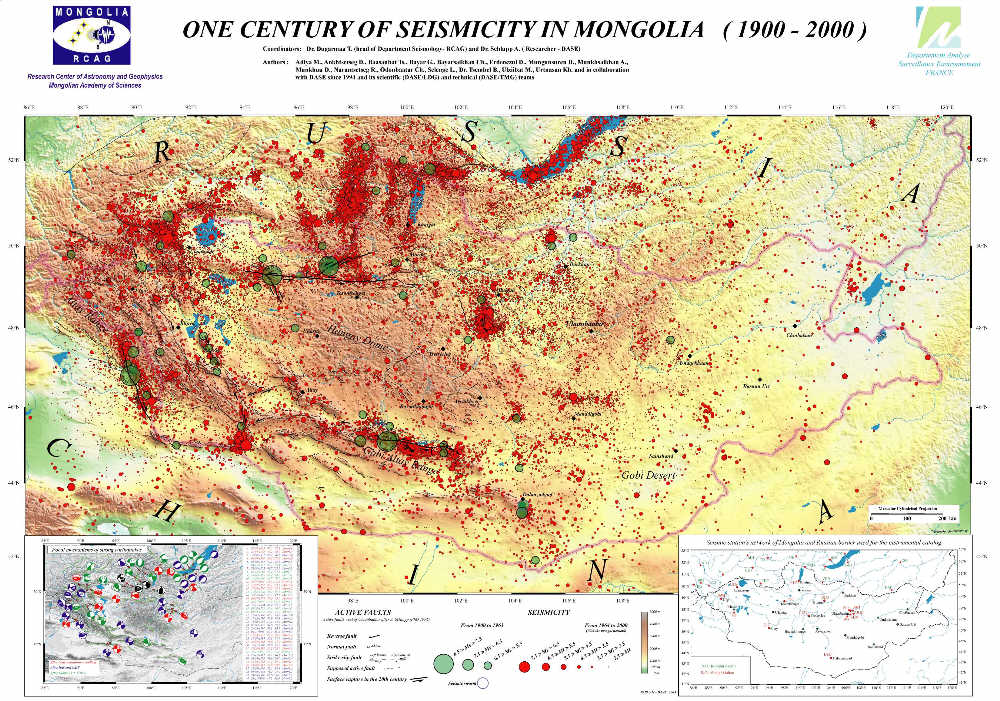
The DASE, in partnership with the RCAG (Research Center of Astronomy and Geophysics of the Mongolian Academy of Sciences), achieved an assessment of seismic risk in the area of Oulan Bator, the capital of Mongolia, where 40% of the country's population is concentrated. This country has suffered four earthquakes with magnitude greater or equal to 8 since 1905.
|
Seismotectonic map of Mongolia. |
To achieve this assessment, the country's seismicity underwent a full review and the attenuation laws were redefined. The resulting map particularly shows that current activity still indicates the faults that ruptured in the beginning of the 20th century, and that the capital's neighboring area is characterized by moderate seismicity. In addition, paleo-seismicity research along a fault-line scarp shows that earthquakes of magnitude around 7 may occur within a 200 km area around the capital. In the Oulan Bator Basin, about 100 measurement points for site effects have been realized. These new data are integrated into the seismic risk quantification procedure. |
|
|
|
A few achievements |
|
|
|
|
|
Hazard study for the following CEA sites: Cadarache, Grenoble, Marcoule, Saclay, Valduc and CESTA |
|
|
Emergency stop system for the TGV Méditerranée high-speed train |
|
|
Hazard study for a retention dam site in the Gard (french "département") |
|
|
Program for the assessment of risks due to seismic effects |
|
|
Assessment of the variation of seismic motion with depth. |
|
| |
|
|
|
)
)
)
)
)