 |
 |
 |
|
 |
|
 |
|
|
|
Scientific files |
|
|
| |
 |
Earthquake of Lourdes
17/11/2006 |
Seismotectonic
 Description of the event Description of the event
On November 17th 2006 at 6:19:50 PM GMT (that is to say 7:19:50 PM local time), an earthquake of magnitude ML 5.4 occurred in the Western Pyrenees at 5km South of Argeles-Gazost (65) (figure 1). Given its magnitude, this event was recorded by the whole stations of the seismic network of the CEA-DASE (figure 2).
This event, clearly felt in the epicentral area up to 20km, was followed within 24 hours, by 164 aftershocks. These latter kept affecting the area, and five earthquakes of magnitude above 3, including two of magnitude above 3.5, were recorded on November 18th and 19th (figure 3).
The characteristics of this earthquake are as follows:
| Date |
17/11/2006 |
| Origin time |
6:19:50 PM GMT |
| Latitude |
42,97 DEG NORTH |
| Longitude |
0,08 DEG WEST |
| Depth |
9 km |
| Magnitude |
5.4 (Ml) |
|
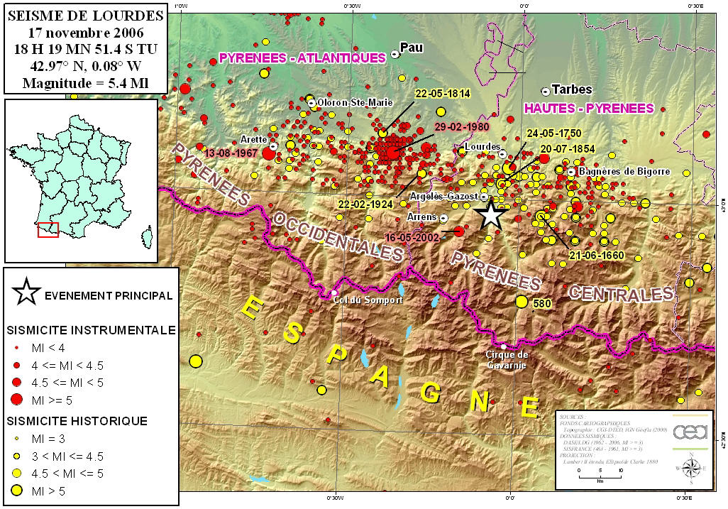
 Figure 1: Seismicity of the Western Pyrenees Figure 1: Seismicity of the Western Pyrenees
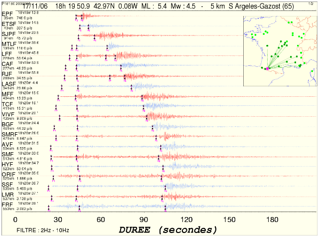
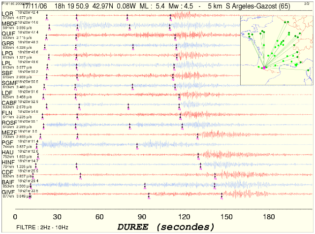
Figure 2: Seismic signals watched on the metropolitan network of the DASE.
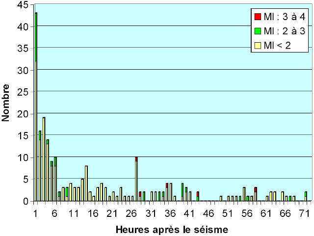
Figure 3: Decrease of aftershocks number functions of time (232 within 72 hours).
Seismicity of the area.
The earthquake took place in the Western Pyrenees (Figure 1). This is the most active region of continental France, seismic wise. We can notice there, on average over ten years, two earthquakes ML LDG > 5 on a 10 000km2 surface. The main earthquakes in this region of Western Pyrenees, during the last millennium, are listed in the array 1.
| Earthquake's name |
Date |
Max intensity (MSK) |
Magnitude* |
| Central Pyrenees, Bigorre
|
21/06/1660 |
VIII-IX |
5,9 |
| Central Pyrenees, Juncalas |
27/05/1750 |
VIII |
5,5 |
| Western Pyrenees, Ossau valley |
22/05/1814 |
VII |
5,1 |
| Central Pyrenees, Argeles Gazost |
20/07/1854 |
VII-VIII |
5,3 |
| Western Pyrenees, Ossau valley |
22/02/1924 |
VII |
4,9 |
| Western Pyrenees, Arette |
13/08/1967 |
VIII |
5,3 |
| Western Pyrenees, Ossau-Arudy valley |
29/02/1980 |
VII-VIII |
5,7 |
Array 1: Main earthquakes in the Western Pyrenees area. (*) = Local Magnitude ML of the LDG for earthquakes after 1962 and magnitude estimated from macro-seismic intensities for earlier earthquakes.
Tectonics.
The earthquake of November 17th, 2006, is located in the Northern Pyrenees Fault (FNP), badly distinct in this area (Figure 4). The FNP is a major accident, towards East-West, which edges Pyrenees in the North and represents the suture of Eurasia and Iberia plates, subjected to a more or less North-South convergence since around 65 Ma. The North-Pyrenees area located in the North of the FNP and in the South of the North Pyrenean frontal overlap (CFNP) is a thin crust area, formed during an extension phase linked to the opening of the Gascoigne Golf, earlier to the compression phase. The axial Palaeozoic area, in the South of the FNP, is characterized by the highest mountaintops of the chain. The general context of tectonic constraints at the origin of the current earthquakes in the Pyrenean chain is a compression nearly North-South (Delouis and al., 1993), the Iberian domain embedding under Eurasia in the North, at least in the central and Eastern part of the chain (Souriau and Granet, 1995).
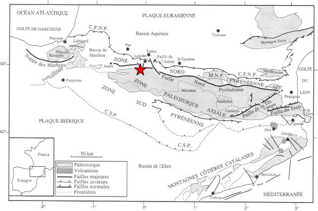
Figure 4: structural map of the Pyrenean Orogen in France (Mattauer and Henry, 1974). Red star: epicentre location of the earthquake of Lourdes on November 17th, 2006.
References.
B. Delouis, H. Haessler, H. Cisternas, L. Rivera, 1993. Stress tensor determination in France and neighbouring regions. Tectonophysics, 221, 413-437.
M. Mattauer et J. Henry, 1974. The Pyrenees. In: Mesozoïc-Cenozoïc Orogenic Belts. Data for orogenic Studies: Alpine-Himalayan Orogens (Ed.A.M.Spencer), Spec. Publ. Geol. Soc. London, 4, 3-21.
Souriau A. & Granet M., (1995). - A tomographic study of the lithosphere beneath the Pyrenees from local and teleseismic data - Journal of Geophysical Research, 100, B9, 18 117-18 134.
Focal mechanism.
The figure 5 shows the comparison between records (in red) and simulations (in blue) on the 3 displacement components. The greyed areas correspond to low frequency parasite signals coming from far-distant earthquakes. The depth and the mechanism have been confirmed by tele-seismic simulations thanks to the amplitude ratio P-pP-sP. We get a pure normal fault mechanism towards an East-West azimuth, coherent with the North-Pyrenean fault's direction.
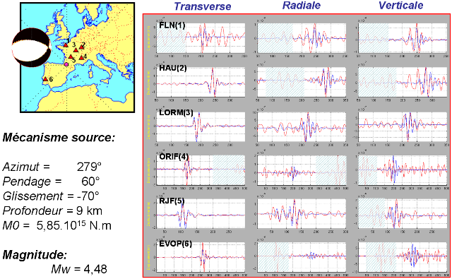
Figure 5: Focal mechanism. |
|
|
|
| |
|
| |
|
|
|
)
)
)
)
)
)