 |
 |
 |
|
 |
|
|
|
Scientifiques files |
|
|
| |

|
Information about earthquake near Dover on 22/05/2015 at 01:52 UT |
On 22 May 2015 at 01h52 UT (02h52 British local time and 03h52 French local time), the Geophysics and Detection Laboratory (LDG) located an earthquake of magnitude 4.4 with an epicentre situated approximately 24 km north of Dover (United Kingdom ) (Figure 1).
|
Onset time |
22/05/2015 at 01:52:20 UT |
|
Location |
24 km north of Dover |
|
Latitude |
51.35° N |
|
Longitude |
1.30° E |
|
Magnitude |
4.4 (Ml) |
|
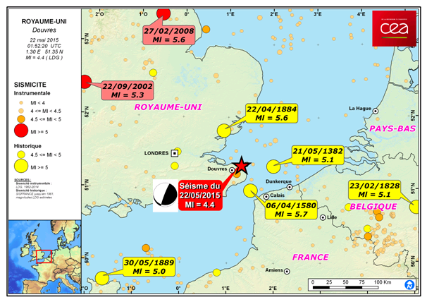
 Figure 1 : Map showing location of seismic event on 22 May 2015 as well as main historical and instrumental earthquakes.
 Tectonic context
The earthquake of 22 May occurred west of the Dover Strait (Figure 1), which is 33 km wide at its narrowest point between Cape Gris Nez and Dover, showing a maximum water depth of 60 m. A network of NW-SE-trending strike-slip faults cuts across the strait (Figure 2). These Variscan tectonic structures were reactivated from Permian times onward in response to compression resulting from the alpine and Pyrenean collisions as well as ridge-push from the North Atlantic plate boundary and processses related to deglaciation in northern Europe.
Historical earthquakes
While the Dover Strait is regarded as an area of weak to moderate seismicity, it has nevertheless been affected by two of the most powerful British earthquakes (epicentral intensity of VII to VIII MSK); these events occurred on 21 May 1382 and 6 April 1580 (Musson, 2004; Musson, 1996) and had a large macroseismic extent of more than 400 km, the former being located in the North Sea between Flanders and Kent and the latter in the Dover Strait (Fig. 1). Since 1580, only weaker earthquakes have occurred in this region.
The event of 6 April 1580, sometimes described as two earthquakes occurring at 12 hour’s interval (Haslett and Bryant, 2008), is known as the “London earthquake”, where it was strongly felt. It also affected France: victims were reported in Calais in particular, and documented damage extended at least as far as Rouen and Pontoise. The most important damage occurred in Calais and Lille (Neilson et al., 1984). The shocks generated landslides, for example in Dover where a limestone cliff face collapsed into the sea carrying away part of the castle (Melville, 1981; Melville et al., 1996).
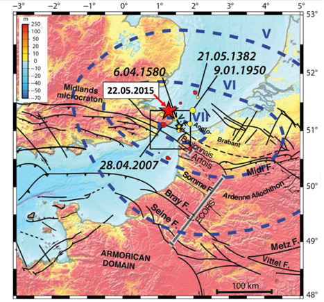
Figure 2 : Tectonic structures and historical seismicity of the Dover Strait, with isoseimal lines (blue dashed lines) for the 1580 earthquake (yellow star) (After Roger and Gunnell, 2012). The red star indicated the location of the seismic event of 22 May 2015 as determined by CEA/DASE
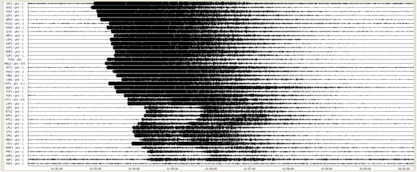
Figure 3 : Seismic signals from the Dover earthquake of 22/05/2015 recorded at 41 seismic stations of the DASE network
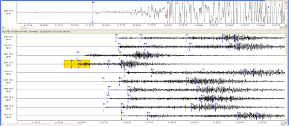
Figure 4 : Processing of seismic signals from the Dover earthquake of 22/05/2015 recorded at seismic stations of the DASE network
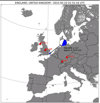
Figure 5 : Seismic source inversion for the earthquake of 22 May 2015, obtained at CENALT using W phase algorithm (Kanamori and Rivera, 2008) on 4 seismic stations in Europe.
- EMSC : page de l’événement :
- Kanamori H. and Rivera L.(2008), Source inversion of W phase: speeding up seismic tsunami warning, Geophys. J. Int., 175, 222–238, doi:10.1111/j.1365-246X.2008.03887.x.
- Melville C. (1981), The historical seismicity of England, Disasters 5, 369-376, doi:10.1111/j.1467-7717.1981.tb01109.x.
- Melville C., Levret A., Alexandre P., Lambert J., Vogt J. (1996), Historical seismicity of the Strait of Dover-Pas de Calais, Terra Nova 8, 626-647, doi:10.1111/j.1365-3121.1996.tb00792.x.
- Musson R. M. W. (1996), The seismicity of the British Isles, Ann. Geofis. 39, 463-469, doi:10.440/ag-3982.
- Musson R. M. W. (2004), A critical history of British earthquakes, Ann. Geophys. 47, 597-609, doi:10.4401/ag-3325.
- Neilson G., Musson R. M. W., Burton P. W. (1984), The “London” earthquake of 1580, April 6, Eng. Geol. 20, 113-141, doi:10.1016/0013-7952(84)90048-6.
- Roger J. and Gunnell Y. (2012), Vulnerability of the Dover Strait to coseismic tsunami hazards: insights from numerical modelling, Geophys. J. Int., 188, 680–686, doi:10.1111/j.1365-246X.2011.05294.x.
|
|
|
)
)
)
)
)