| |

 |
Algiers area earthquake |
 Detection and location during the alert phase Detection and location during the alert phase
On Wednesday May 21, 2003 at 6:44 pm (UT) (8:44 pm in France), a high-magnitude earthquake occurred 80 kilometers north-east of Algiers. It triggered an alert on the CEA-DASE seismic monitoring network. The duty seismologist, who had been warned automatically, sent an initial analysis of the event to the relevant authorities 40 minutes later. He in particular gave an initial estimate of the epicenter's location and the earthquake's magnitude.
Since the event occurred outside national territory, the alert was first relayed by the EMSC (European-Mediterranean Seismological Centre), which is located on DASE premises (in Bruyères-le-Châtel), and then by the DASE a few minutes later.
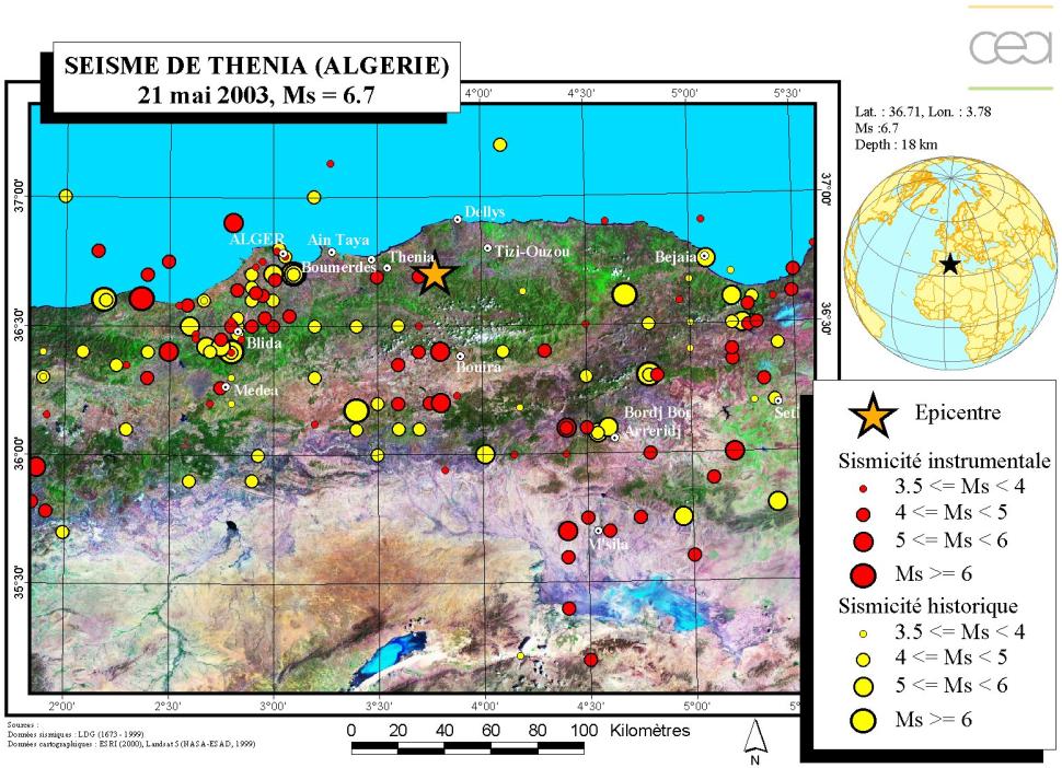
 Event location
The earthquake, that occurred in the immediate vicinity of urban areas, caused significant damage and loss of life.
Friday May 23, 2003, 10:36 am
Earthquake in Algeria: 1092 lives lost, hundreds reported missing
ALGER (AFP) - According to a first report issued by the Algerian Ministry of Home Affairs on Thursday evening, a destructive earthquake occurred in Algiers and its surrounding area on Wednesday night. At least 1092 people were killed, 6782 injured and hundreds of people are reported missing. The worst toll was in the Boumerdès Department (50 km east of Algiers) with 624 lives lost, and in the Algiers Department with 457 lives lost, according to the Ministry.
In the small seaside town of Boumerdès, the damage caused by the earthquake was particularly impressive, an AFP journalist witnessed. Dozens of formerly huge buildings have been flattened to the ground. This earthquake is already the deadliest in Algeria on record since 1980, when an earthquake of magnitude 7.5 on the open-ended Richter scale occurred, killing 3000 people. |
|
Characterization and location during the routine analysis
The following morning, CEA-DASE analysts, whose task is to monitor seismicity, provided a more precise location of the earthquake. This analysis above all helped to narrow down its location (used to confirm epicenter location), determine its depth (18 km, this relatively shallow depth is typical for events in this area), and to estimate the various magnitudes associated with the event (an assessment of the Ms magnitude based on surface seismic waves, which propagate more slowly, provides a more precise estimate for strong earthquakes):
| Date |
21/05/2003 |
| Origin time |
6:44:21:9 pm (UT) |
| Latitude |
36 DEG 43
MN NORTH (36.71) |
| Longitude |
03 DEG 47
MN EAST (3.78) |
| Depth |
18 km |
| Magnitude |
6.2 (Ml)
regional magnitude
6.7 (Ms) surface magnitude
6.5 (Mb) body magnitude (teleseismic signals)
6.9 (Mw) |
|
Over a hundred new events were recorded in the 36 hours following the event, including 7 major aftershocks which triggered the automatic system warning the duty seismologist. The chart below lists the characteristics of these events:
|
|
Date |
Origin time (UT) |
Latitude (N) |
Longitude (E) |
Magnitude (Ml) |
|
Main event |
21/05/2003 |
6:44 pm |
36.71 |
3.78 |
6.2 |
|
Aftershock #1 |
21/05/2003 |
10:04 pm |
37.18 |
3.87 |
5.0 |
|
Aftershock #2 |
21/05/2003 |
11:24 pm |
36.54 |
3.61 |
4.5 |
|
Aftershock #3 |
22/05/2003 |
01:39 am |
36.49 |
3.64 |
5.2 |
|
Aftershock #4 |
22/05/2003 |
03:14 am |
37.16 |
3.55 |
5.2 |
|
Aftershock #5 |
22/05/2003 |
11:11 am |
37.10 |
3.92 |
4.2 |
|
Aftershock #6 |
22/05/2003 |
1:57 pm |
36.95 |
4.08 |
4.5 |
|
Aftershock #7 |
23/05/2003 |
00:09 am |
37.08 |
3.82 |
4.6 |
|
Seismotectonic setting
This earthquake occurred at a plate boundary. The African plate is converging north-north-west under the Eurasian plate at a rate of approximately 6 mm per year. This is creating a 50 to 100 km wide area of intense tectonic deformation. This area is characterized by the recent North African reliefs where numerous reverse or strike-slip faults can be found.
The first detailed analyses of the May 21, 2003 earthquake confirm that it was caused by compression on a WSW-ENE oriented fault. This is therefore perfectly compatible with the local seismotectonic context.
The last century witnessed numerous major earthquakes in Algeria, yet the eastern part of Algiers appears to have been largely spared these events. The May 21, 2003 earthquake is the largest since the El Asnam earthquake that occurred on October 10, 1980. It registered a magnitude of Mw 7.3 and occurred approximately 200 km west of today's earthquake. Another destructive earthquake had already occurred in this area in 1954. Several significant earthquakes also occurred in the western part of Algiers, particularly in 1989, 1990 and 1996.
|
)