 |
OLERON EARTHQUAKE (CHARENTE-MARITIME) April 18, 2005
|
 Description of the event Description of the event
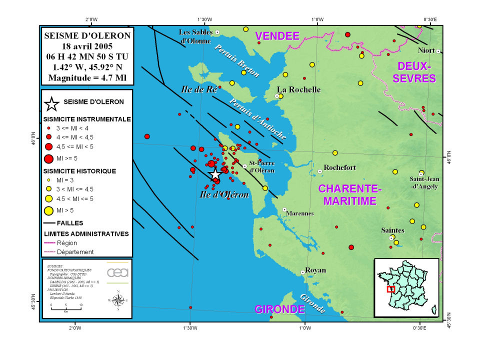
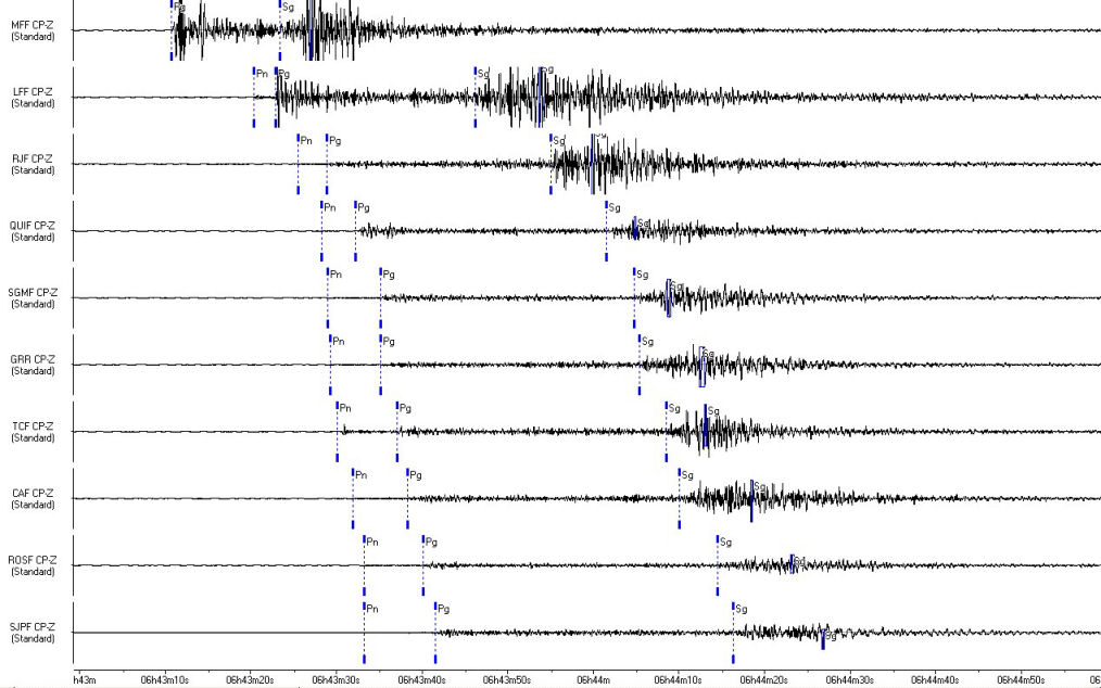
On April 18, 2005 at 06:42:50 am UT (i.e. 8:42:50 am local time), an earthquake of local magnitude ML = 4.7 occurred on the island of Oléron, about 10 km west-south-west of Saint Pierre d'Oléron (Charente Maritime), at latitude 45.92 N and longitude 1.42 W (Figure 1). Given its magnitude, this event was recorded on all the CEA-DASE seismic network stations (Figure 2).
The event was followed by two aftershocks of magnitude 3.0 and 3.4 within ten minutes of the main shock.

Figure 1: Location of the event of April 18, 2005 at 06:42 am UT (white star) and instrumental seismicity (red dots) and historical seismicity (yellow dots) recorded in the LDG database.

Figure 2: Seismic signals recorded for the April 18, 2005 earthquake on the 10 stations nearest to the epicenter.
The main event triggered an alert on the CEA-DASE seismic monitoring network which was quickly sent to the Civil Defense Office and the relevant authorities by the duty seismologist. This event was felt on the island and also on the coast (La Rochelle, Rochefort).
The following chart includes the characteristics of the main events that occurred within 4 hours of the main earthquake.
| Main event |
Date |
Time (UT) |
Latitude (°) |
Longitude (°) |
Magnitude (ML) |
| 18/04/2005 |
06:42:50 am |
45.92 N |
1.42 W |
4.69 |
| Aftershocks |
18/04/2005 |
06:54:00 am |
45.93 N |
1.43 W |
3.03 |
18/04/2005 |
06:54:49 am |
45.96 N |
1.38 W |
3.36 |
An earthquake of magnitude 4.1 had struck the same area on April 4. An alert message had also been sent out on this occasion.

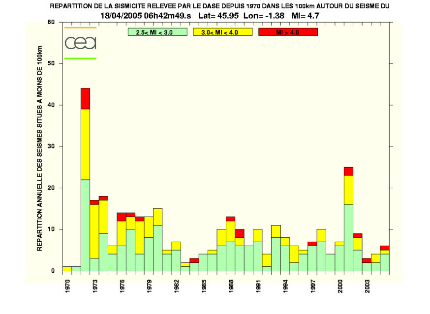
Figure 3 : Histogram of seismicity in the vicinity of the island of Oléron since 1970.
 Previous seismicity and seismotectonic setting Previous seismicity and seismotectonic setting
The April 18, 2005 earthquake is located in an area of relatively significant activity in the recent past.
The Oléron earthquake on September 7, 1972 is the major earthquake of the entire Armorican Massif. Of local magnitude 5.7, it recorded an intensity of VII (MSK). It caused some damage in the area closest to the epicenter (island of Oléron and around La Rochelle), and was felt as far as the Paris area. This is the main event in an area of significant seismic activity, characterized by three episodes of several dozen events, in 1958, from 1972 to 1973 and from 1976 to 1977, and since then several events of a magnitude above 4.
The focal mechanism of the main earthquake on September 7, 1972 shows a right-slip fault (NW-SE), with a relatively strong normal component. It probably occurred on a NW-SE oriented Armorican crustal fault, known as the Oléron fault, situated south of the South-Armorican Shear Zone and clearly visible on the main ECORS northern France and Biscay seismic profiles. This area, located at the southern boundary of the Armorican Massif, is perfectly in keeping with this context which presents a seismicity mainly linked to the principal Late Hercynian strike-slip faults.
The maximum intensity observed in the Armorican Massif is VIII. This intensity was reached a hundred kilometers further north, during the Bouin earthquake which occurred on January 25,1799 in marshland where seismic motion was amplified by site effects. The magnitude of this major earthquake on the scale of the Armorican Massif is of the same order as the Oléron earthquake of September 7, 1972 which, being more recent, is better documented.  Preliminary study of the source mechanism Preliminary study of the source mechanism
The direct simulation using the SH components from the regional recordings of the CEA-DASE Long-Period (LP) sensors shows that the moment of the April 18, 2005 earthquake is 5.10 14 Nm. The focal mechanism of this event appears to be relatively similar to that of the main shock on September 7, 1972 and involve a subvertical NW-SE fault.
More precise information about the mechanism will be available after full inversion of all the seismometer components.
|