 |
 |
 |
|
 |
|
|
|
Scientifiques files |
|
|
| |

|
Earthquake of magnitude 7.5 in the north of Afghanistan |
 Source mechanism
The source mechanism obtained by inversion of the W phase at teleseismic distances (Figures 1 and 2) is consistent with the mechanisms obtained by other seismological organizations and indicates that this earthquake took place according to a reverse-fault mechanism with an azimuth of WNW-ESE:
- either along a steeply dipping discontinuity with a SSE-directed vergence
- or according to a weaker dip with a NNE-directed vergence.
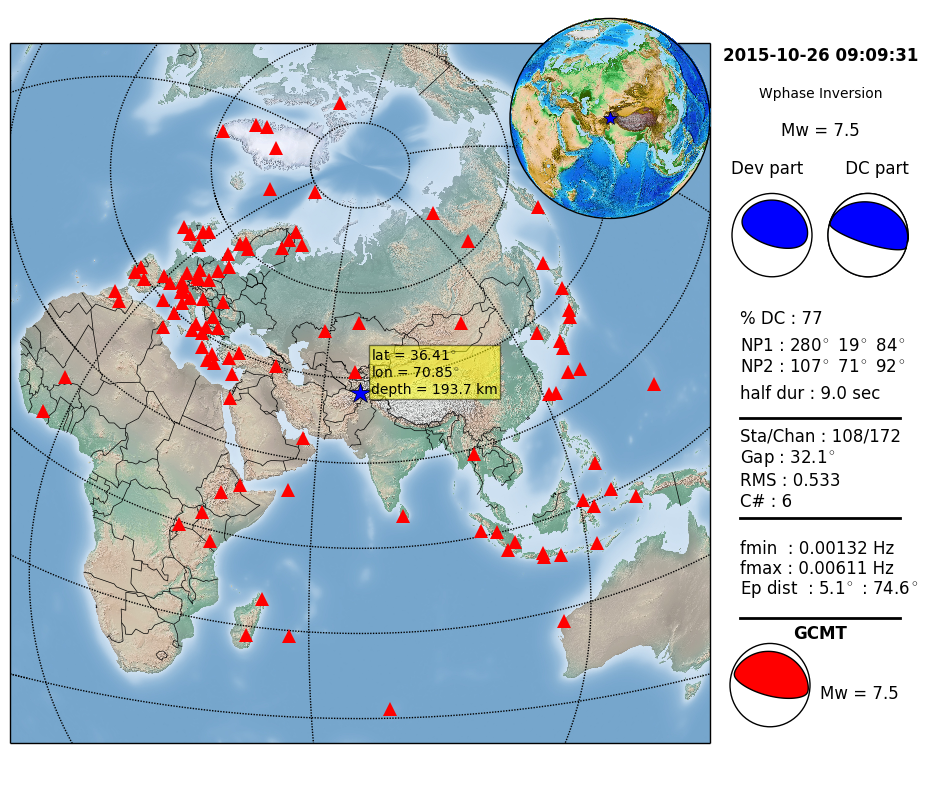
 Figure 1: Map showing location of the earthquake of 26 October 2015 (blue star) in the north of Afghanistan, with the seismological stations (red triangles) used to determine the moment tensor of this earthquake by inversion of the W phase at teleseismic distances (Kanamori and Rivera, 2008). On the right, the deviatoric solution (Dev part) and the double couple component (CD part) of the moment tensor obtained by inversion of the W phase are shown in blue. For comparison, the seismic moment tensor determined by GCMT is shown in red on the right at the bottom, representing the international benchmark in terms of Centroid Moment Tensor solutions.
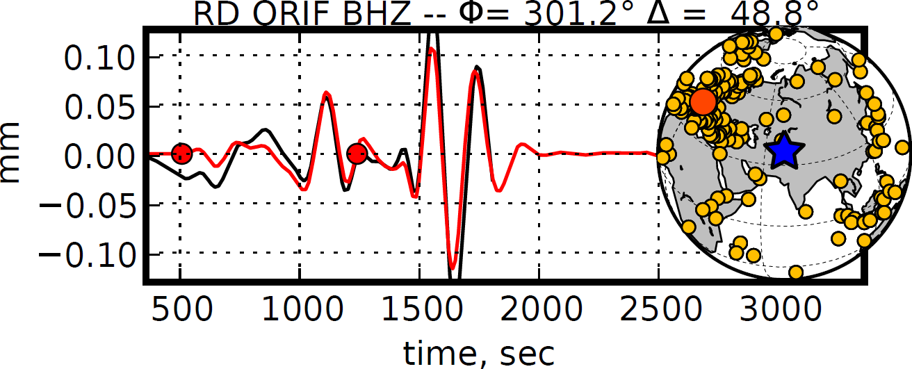
Figure 2: Example of vertical-component seismogram recorded at the ORIF station located in the French Alps (orange circle on the globe) at 48.8° from the earthquake of 26 October 2015 (blue star). This recording at the ORIF station as well as the seismograms of 107 other stations (yellow circles on the globe) were used for inversion of the W phase. Note the satisfactory agreement between the observation in black and the simulation in red. The W phase is comprised between the two red circles.
Seismotectonic context
At the latitude of this earthquake, the Indian plate is moving northward and is colliding with the Eurasian plate at a rate of approximately 37 mm per year. The earthquakes in this region of northern Afghanistan are the direct result of convergence between the Indian and Eurasian plates. This collision between the Indian and Eurasian plates accounts for the formation of the highest mountain ranges in the world (the Himalayas, Karakoram, Pamirs and Hindu-Kush). The convergence is also expressed by a so-called continent-continent subduction marked by strong seismicity at the plate boundary, extending from the surface to a depth of 250 km. The seismic event of 26 October occurred within this convergent plate boundary zone.
An intermediate-depth earthquake felt at great distance
Earthquakes comparable with the event of 26 October 2015, having focal depths of between 70 and 300 km, are usually called seismic events of “intermediate depth”. Such earthquakes accommodate deformation within the subducted lithosphere, in contrast to surface earthquakes which occur on faults in the crust or at the interface between two tectonic plates. These intermediate-depth earthquakes generally cause less damage than events of the same magnitude occurring close to the surface. On the other hand, major events such as the earthquake of 26 October 2015 are felt at very great distances from their epicentre. However, in the vicinity of the seismic source, the waves are less attenuated than if the seismic event takes place in the more heterogeneous surface crust, where this would lead to greater attenuation of the seismic waves.
Provisional assessment
24 hours after the earthquake, the death toll stands at almost 300. This estimate is likely to rise as relief progressively attains valleys that are very difficult to reach.
Kanamori H. and Rivera L. (2008), Source inversion of W phase: speeding up seismic tsunami warning, Geophys. J. Int., 175, 222–238, doi:10.1111/j.1365-246X.2008.03887.x.
|
|
|
)
)